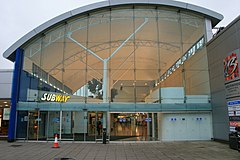
Birchwood
| Birchwood | |
|---|---|
 The Birchwood Shopping Centre |
|
| Birchwood shown within Cheshire | |
| Population | 11,395 (2001) |
| OS grid reference | SJ647911 |
| Civil parish |
|
| Unitary authority | |
| Ceremonial county | |
| Region | |
| Country | England |
| Sovereign state | United Kingdom |
| Post town | WARRINGTON |
| Postcode district | WA3 |
| Dialling code | 01925 |
| Police | Cheshire |
| Fire | Cheshire |
| Ambulance | North West |
| EU Parliament | North West England |
| UK Parliament | |
Birchwood is a civil parish in north east Warrington, Cheshire, England with a population of 11,395 (as at the 2001 census). Historically part of Lancashire, it was built during the time of much expansion in Warrington as it became a "new town". Birchwood is separated into three residential estates: Gorse Covert (grid ref SJ665925, population 2,790), Oakwood (grid ref SJ656914, population 4,381) and Locking Stumps (grid ref SJ645918, population 2,759), with all the main facilities grouped around the centre.
The area east of Birchwood is mainly birch forests and Risley Moss, part of the Mersey Forest. Risley Moss is a Site of Special Scientific Interest. The bulk of Birchwood is built on the site of the former ROF Risley Royal Ordnance Factory, with Birchwood Forest Park lying in the centre, in which the old bunkers from the factory form part of the landscape.
"The surface, at a distance, looks black and dirty, and will bear neither horse nor man….. What nature meant by such a useless production 'tis hard to imagine, but the land is entirely to waste" are the words of Daniel Defoe as he rode through Risley in 1724. (Later part of the Risley area was renamed Birchwood as the Warrington 'New town' development).
In the past travellers avoided the Risley (Birchwood) area because it of its dangerous mossland, however gradually over time much of the fertile mossland was reclaimed and turned into farm land. With the advent of the Second World War, 927 acres (3.8 km²) of agricultural land was changed into a massive Royal Ordnance Factory, ROF Risley. The location was chosen because the low lying mist and cloud helped camouflage the factory from the air; according to a local builder: "It was very lonely and misty at night, and that's why the factory was constructed there ... it was usually covered with a mist or cloud. It was hard to see it in the day time, you know". Although the location of the factory was known by the German Luftwaffe, the factory was bombed only once during the war.
...
Wikipedia

