Big Springs, Nebraska
| Big Springs, Nebraska | |
|---|---|
| Village | |

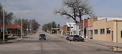
Downtown Big Springs, looking north up Pine Street
|
|
 Location of Big Springs, Nebraska |
|
| Coordinates: 41°3′48″N 102°4′30″W / 41.06333°N 102.07500°WCoordinates: 41°3′48″N 102°4′30″W / 41.06333°N 102.07500°W | |
| Country | United States |
| State | Nebraska |
| County | Deuel |
| Area | |
| • Total | 0.44 sq mi (1.14 km2) |
| • Land | 0.44 sq mi (1.14 km2) |
| • Water | 0 sq mi (0 km2) |
| Elevation | 3,373 ft (1,028 m) |
| Population (2010) | |
| • Total | 400 |
| • Estimate (2012) | 406 |
| • Density | 909.1/sq mi (351.0/km2) |
| Time zone | Mountain (MST) (UTC-7) |
| • Summer (DST) | MDT (UTC-6) |
| ZIP code | 69122 |
| Area code(s) | 308 |
| FIPS code | 31-04895 |
| GNIS feature ID | 0827434 |
Big Springs is a village in Deuel County, Nebraska, United States. The population was 400 at the 2010 census.
The first name of the settlement was "Lone Tree", after a large cottonwood tree standing alone on the prairie near the town. It was believed to be over 100 years old at the time of first settlement and could be seen by riders on the Pony Express and travelers on the Oregon Trail. Sam Bass's gang reportedly divided $60,000 in loot under the tree from an 1877 robbery of a Union Pacific train.
The railroad named this stop "Big Springs" in 1867. Spring water from near the track was used by steam locomotives until 1950.
Big Springs was platted in 1884, and named for the stream that runs through town. The Big Springs post office, established in 1884, was officially called Bigspring until 1943. The village of Big Springs was incorporated in 1917.
The county fair was held in Big Springs from 1889-1932. Chappell, the only other town in the county, became the county seat.
In 1884, the first church services were held by the Rev. E. E. Mount in the Phelps Hotel. The first church in the county, called Prospect Church, was a sod building constructed 9 miles (14 km) north of town in 1887.
Big Springs is located at 41°3′48″N 102°4′30″W / 41.06333°N 102.07500°W (41.063399, -102.075111).
According to the United States Census Bureau, the village has a total area of 0.44 square miles (1.14 km2), all of it land.
...
Wikipedia
