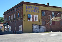
Big Sandy, Montana
| Big Sandy, Montana | |
|---|---|
| Town | |
 |
|
 Location of BigSandy, Montana |
|
| Coordinates: 48°10′40″N 110°6′53″W / 48.17778°N 110.11472°WCoordinates: 48°10′40″N 110°6′53″W / 48.17778°N 110.11472°W | |
| Country | United States |
| State | Montana |
| County | Chouteau |
| Area | |
| • Total | 0.44 sq mi (1.14 km2) |
| • Land | 0.44 sq mi (1.14 km2) |
| • Water | 0 sq mi (0 km2) |
| Elevation | 2,700 ft (823 m) |
| Population (2010) | |
| • Total | 598 |
| • Estimate (2015) | 593 |
| • Density | 1,359.1/sq mi (524.8/km2) |
| Time zone | Mountain (MST) (UTC-7) |
| • Summer (DST) | MDT (UTC-6) |
| ZIP code | 59520 |
| Area code(s) | 406 |
| FIPS code | 30-06250 |
| GNIS feature ID | 0768824 |
Big Sandy is a town in Chouteau County, Montana, United States. The population was 598 at the 2010 census. Big Sandy, Montana, is where the Big Bud 747, the largest farm tractor in the world, is located. The Lewis and Clark Trail, following U.S. Route 87, goes through Big Sandy and in 2011 the town was named in a list of "Most Livable Small Towns" by Montana Outdoors magazine.
Big Sandy is located at 48°10′40″N 110°6′53″W / 48.17778°N 110.11472°W (48.177872, -110.114630).
According to the United States Census Bureau, the town has a total area of 0.44 square miles (1.14 km2), all of it land.
According to the Köppen Climate Classification system, Big Sandy has a semi-arid climate, abbreviated "BSk" on climate maps.
As of the census of 2010, there were 598 people, 276 households, and 161 families residing in the town. The population density was 1,359.1 inhabitants per square mile (524.8/km2). There were 337 housing units at an average density of 765.9 per square mile (295.7/km2). The racial makeup of the town was 93.1% White, 0.2% African American, 2.8% Native American, 0.8% Asian, 0.7% Pacific Islander, 0.3% from other races, and 2.0% from two or more races. Hispanic or Latino of any race were 1.3% of the population.
...
Wikipedia
