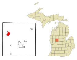
Big Rapids, Michigan
| Big Rapids, Michigan | |
|---|---|
| City | |
 Location of Big Rapids, Michigan |
|
| Coordinates: 43°41′56″N 85°28′52″W / 43.69889°N 85.48111°W | |
| Country | United States |
| State | Michigan |
| County | Mecosta |
| Area | |
| • Total | 4.48 sq mi (11.60 km2) |
| • Land | 4.36 sq mi (11.29 km2) |
| • Water | 0.12 sq mi (0.31 km2) |
| Elevation | 925 ft (282 m) |
| Population (2010) | |
| • Total | 10,601 |
| • Estimate (2012) | 10,702 |
| • Density | 2,431.4/sq mi (938.8/km2) |
| Time zone | Eastern (EST) (UTC-5) |
| • Summer (DST) | EDT (UTC-4) |
| ZIP code | 49307 |
| Area code(s) | 231 |
| FIPS code | 26-08300 |
| GNIS feature ID | 1619197 |
| Website | Big Rapids official website |
Big Rapids is a city in the U.S. state of Michigan. The population was 10,601 at the 2010 census. It is the county seat of Mecosta County. The city is located within Big Rapids Township, but is politically independent. Big Rapids is home of the main campus of Ferris State University, a four-year public university, well known for its College of Pharmacy and the Michigan College of Optometry, as well as its NCAA Division I hockey team, the Bulldogs.
Big Rapids was settled in 1855 by George French and his brother Zera. It became the seat of Mecosta County in 1859. The village was platted in 1859. It was incorporated as a city in 1869.
According to the United States Census Bureau, the city has a total area of 4.48 square miles (11.60 km2), of which 4.36 square miles (11.29 km2) is land and 0.12 square miles (0.31 km2) is water. Like most of the central Michigan area, it lies on the ancient sea bed and has a sandy subsoil which lies above an iron ore base. The Muskegon River runs through Big Rapids, passing both Ferris State University and the local middle school on its way to Lake Michigan. Numerous small lakes are within a few miles of the city.
The Fred Meijer White Pine Trail, a 92-mile multi-use trail from Grand Rapids to Cadillac, MI, passes through Big Rapids.
As of the census of 2010, there were 10,601 people, 3,330 households, and 1,323 families residing in the city. The population density was 2,431.4 inhabitants per square mile (938.8/km2). There were 3,623 housing units at an average density of 831.0 per square mile (320.9/km2). The racial makeup of the city was 88.0% White, 6.8% African American, 0.7% Native American, 1.5% Asian, 0.6% from other races, and 2.5% from two or more races. Hispanic or Latino of any race were 2.4% of the population.
...
Wikipedia
