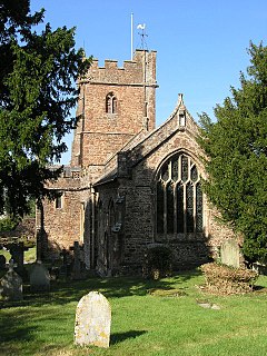
Bicknoller
| Bicknoller | |
|---|---|
 Church of St George, Bicknoller |
|
| Bicknoller shown within Somerset | |
| Population | 371 |
| OS grid reference | ST110396 |
| Civil parish |
|
| District | |
| Shire county | |
| Region | |
| Country | England |
| Sovereign state | United Kingdom |
| Post town | TAUNTON |
| Postcode district | TA4 |
| Dialling code | 01984 |
| Police | Avon and Somerset |
| Fire | Devon and Somerset |
| Ambulance | South Western |
| EU Parliament | South West England |
| UK Parliament | |
Bicknoller is a village and civil parish on the western slopes of the in the English county of Somerset.
Administratively, the civil parish falls within the West Somerset local government district within the Somerset shire county, with administrative tasks shared between county, district and parish councils. In 2011, the parish had a population of 371.
The village is on the routes of the Coleridge Way and the Macmillan Way West.
Above the village lies Trendle Ring, an Iron Age settlement.
The parish of Bicknoller was part of the Williton and Freemanners Hundred.
The village was known in 1291 as Bykenalre which means Bica's alder tree.
From 1430 to 1857 the manor was held by Wells Cathedral.
The parish council has responsibility for local issues, including setting an annual precept (local rate) to cover the council’s operating costs and producing annual accounts for public scrutiny. The parish council evaluates local planning applications and works with the local police, district council officers, and neighbourhood watch groups on matters of crime, security, and traffic. The parish council's role also includes initiating projects for the maintenance and repair of parish facilities, as well as consulting with the district council on the maintenance, repair, and improvement of highways, drainage, footpaths, public transport, and street cleaning. Conservation matters (including trees and listed buildings) and environmental issues are also the responsibility of the council.
...
Wikipedia

