Bibb County, Alabama
| Bibb County, Alabama | |
|---|---|

|
|
 Location in the U.S. state of Alabama |
|
 Alabama's location in the U.S. |
|
| Founded | February 7, 1818 |
| Named for | William W. Bibb |
| Seat | Centreville |
| Largest city | Brent |
| Area | |
| • Total | 626 sq mi (1,621 km2) |
| • Land | 623 sq mi (1,614 km2) |
| • Water | 3.6 sq mi (9 km2), 0.6% |
| Population (est.) | |
| • (2015) | 22,583 |
| • Density | 37/sq mi (14/km²) |
| Congressional district | 6th |
| Time zone | Central: UTC-6/-5 |
| Website | www |
|
Footnotes:
|
|
Footnotes:
Bibb County is a county in the U.S. state of Alabama. As of the 23rd Decennial 2010 United States Census its population was 22,915. The county seat is Centreville. Its name is in honor of William W. Bibb, (1781-1820), the Governor of Alabama Territory, (1817-1819), and the first Governor of Alabama, (1819-1820, when he died), who is also the namesake for Bibb County, Georgia where he began his political career. It is a "prohibition" or dry county; however, the cities of West Blocton, Brent, and Centreville have all become "wet", by allowing the sale of alcoholic beverages.
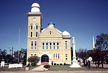
The Bibb County Courthouse is located in the county seat of Centreville.
Cahawba County was established ("erected") on February 7, 1818, named for the Cahawba River, (now more commonly spelled as Cahaba River). This name came from the Choctaw language word meaning "water above." On December 4, 1820, it was renamed as Bibb County.
With a large population of slaves before the American Civil War, during and after Reconstruction whites worked to dominate and establish white supremacy. In addition to laws that the state legislature passed, creating a new constitution that raised barriers to voter registration and excluding freedmen from the political process, this county ranked with two others: Dallas and Pickens, as having the third-highest number of lynchings in the state. These extrajudicial murders were a form of racial terrorism by the whites against blacks.
According to the U.S. Census Bureau, the county has a total area of 626 square miles (1,620 km2), of which 623 square miles (1,610 km2) is land and 3.6 square miles (9.3 km2) (0.6%) is water.
...
Wikipedia
