Bethel Township, Berks County, Pennsylvania
| Bethel Township, Berks County, Pennsylvania |
|
| Township | |
|
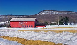
Round Top Valley Farm in Bethel Township
|
|
| Country | United States |
|---|---|
| State | Pennsylvania |
| County | Berks |
| Elevation | 741 ft (225.9 m) |
| Coordinates | 40°30′03″N 76°22′35″W / 40.50083°N 76.37639°WCoordinates: 40°30′03″N 76°22′35″W / 40.50083°N 76.37639°W |
| Area | 42.2 sq mi (109.3 km2) |
| - land | 42.2 sq mi (109 km2) |
| - water | 0.04 sq mi (0 km2), 0.09% |
| Population | 4,112 (2010) |
| Density | 98.7/sq mi (38.1/km2) |
| Timezone | EST (UTC-5) |
| - summer (DST) | EDT (UTC-4) |
| Area code | 610, 717 |
Bethel Township is a township in Berks County, Pennsylvania, United States. The population was 4,112 at the 2010 census.
Spannuth Mill was listed on the National Register of Historic Places in 1990.
According to the United States Census Bureau, the township has a total area of 42.2 square miles (109 km2), of which, 42.2 square miles (109 km2) is land and 0.04 square miles (0.10 km2) (0.05%) is water. It is drained by the Little Swatara Creek into the Swatara Creek and the Susquehanna River. Its natural northern boundary is Blue Mountain.
Bethel Township's main east-to-west route is Interstate 78/U.S. Route 22, which interchanges with the north-to-south Route 183, Route 419, Route 501, and Route 645. Its villages include Bethel, Crosskill Mills (also in Tulpehocken Township,) Frystown, Grimes, Meckville, and Schubert.
Adjacent townships
As of the census of 2000, there were 4,166 people, 1,466 households, and 1,150 families residing in the township. The population density was 98.7 people per square mile (38.1/km²). There were 1,551 housing units at an average density of 36.7/sq mi (14.2/km²). The racial makeup of the township was 97.36% White, 0.55% African American, 0.10% Native American, 0.65% Asian, 0.77% from other races, and 0.58% from two or more races. Hispanic or Latino people of any race were 1.56% of the population.
...
Wikipedia


