Bet-Djibrin
| Bayt Jibrin | |
|---|---|

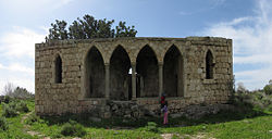
Historic Bayt Jibrin mansion
|
|
| Arabic | بيت جبرين |
| Also spelled | Beit Jibrin |
| Subdistrict | Hebron |
| Coordinates | 31°36′19″N 34°53′54″E / 31.60528°N 34.89833°ECoordinates: 31°36′19″N 34°53′54″E / 31.60528°N 34.89833°E |
| Palestine grid | 140/112 |
| Population | 2,430 (1945) |
| Area | 56,185 dunams 56.2 km² |
| Date of depopulation | October 29, 1948 |
| Cause(s) of depopulation | Military assault by Yishuv forces |
| Current localities | Beit Guvrin (kibbutz) |
Bayt Jibrin (Arabic: بيت جبرين, also transliterated Beit Jibrin; Hebrew: בית גוברין, Beit Gubrin), was a Palestinian Arab village located 21 kilometers (13 mi) northwest of the city of Hebron. The village had a total land area of 56,185 dunams or 56.1 km2 (13,900 acres), of which 0.28 km2 (69 acres) were built-up while the rest remained farmland.
During the 8th century BCE, the village was part of the Kingdom of Judah. During the days of Jewish king Herod the town was the administrative center for the district of Idumea. After the turmoil of the First Jewish-Roman War and the Bar Kokhba revolt the town became a thriving Roman colony and a major administrative center under the name of Eleutheropolis. In the early 7th century CE, Bayt Jibrin was conquered by Muslim forces led by 'Amr ibn al-'As. Under the Crusaders in the 12th century, it was known as Beth Gibelin, and had a population of 1,500, compared to 100-150 in the average village of the time. It fell to the Mamluks and then the Ottoman Turks. In the 19th century, the al-'Azza family took control of Bayt Jibrin and unsuccessfully attempted to rebel against the Ottomans, ending in the exile and execution of local leaders.
...
Wikipedia

