Besenbüren
| Besenbüren | ||
|---|---|---|
 |
||
|
||
| Coordinates: 47°19′N 8°21′E / 47.317°N 8.350°ECoordinates: 47°19′N 8°21′E / 47.317°N 8.350°E | ||
| Country | Switzerland | |
| Canton | Aargau | |
| District | Muri | |
| Area | ||
| • Total | 2.38 km2 (0.92 sq mi) | |
| Elevation | 455 m (1,493 ft) | |
| Population (Dec 2015) | ||
| • Total | 607 | |
| • Density | 260/km2 (660/sq mi) | |
| Postal code | 5627 | |
| SFOS number | 4226 | |
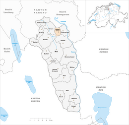
| Surrounded by | Aristau, Boswil, Bünzen, Hermetschwil-Staffeln, Rottenschwil | |
| Website |
www SFSO statistics |
|
Besenbüren is a municipality in the district of Muri in the canton of Aargau in Switzerland.
The first indication of human settlement near Besenbüren are paleo- and mesolithic items that were discovered in the Forenmoos. The modern municipality of Besenbüren is first mentioned in the Acta Murensia, which was first drawn up in 1160 but included a number of various older documents, as Besenbürren. The major landholders in the Middle Ages in Besenbüren were Muri and Engelberg Abbeys. Under the Habsburgs it belonged to the Muri district. After 1415 it belonged to the Boswil district. The rights that the Hermann of Heidegg received after the conquest of the Aargau by the Swiss Conderation remained with his family until 1617, when they were transferred to Muri Abbey.
In the 19th century, agricultural employment and the straw plaiting industry provided nearly all the jobs in the municipality. In the second half of the 19th century the population decreased as a result of fires, emigration and land scarcity. The bad traffic situation and the small territory led to no industrial development. In 1990, the agricultural sector still provided 33% of the jobs, while the services sector provides 47%.
Besenbüren has an area, as of 2009[update], of 2.38 square kilometers (0.92 sq mi). Of this area, 1.58 km2 (0.61 sq mi) or 66.4% is used for agricultural purposes, while 0.47 km2 (0.18 sq mi) or 19.7% is forested. Of the rest of the land, 0.29 km2 (0.11 sq mi) or 12.2% is settled (buildings or roads) and 0.01 km2 (2.5 acres) or 0.4% is unproductive land.
Of the built up area, industrial buildings made up 1.3% of the total area while housing and buildings made up 5.5% and transportation infrastructure made up 4.2%. Out of the forested land, all of the forested land area is covered with heavy forests. Of the agricultural land, 55.5% is used for growing crops and 9.7% is pastures, while 1.3% is used for orchards or vine crops.
...
Wikipedia


