Berowra Valley National Park
|
Berowra Valley National Park New South Wales |
|
|---|---|
|
IUCN category II (national park)
|
|

Berowra Creek
|
|
| Nearest town or city | Berowra |
| Coordinates | 33°40′54″S 151°06′04″E / 33.68167°S 151.10111°ECoordinates: 33°40′54″S 151°06′04″E / 33.68167°S 151.10111°E |
| Established | September 2012 |
| Area | 38.84 km2 (15.0 sq mi) |
| Managing authorities | NSW National Parks & Wildlife Service |
| Website | Berowra Valley National Park |
| See also | Protected areas of New South Wales |
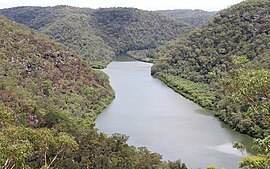
The Berowra Valley National Park is a protected national park that is located in the North Shore region of Sydney, New South Wales, in eastern Australia. The 3,884-hectare (9,600-acre) national park is situated approximately 20 kilometres (12 mi) north of the Sydney central business district, and approximately 1 kilometre (0.62 mi) from each of Thornleigh, Pennant Hills, Westleigh, Dural, and Hornsby Heights. Located within the Sydney Basin, the park is part of the dissected Hornsby Plateau which is dominated by Hawkesbury Sandstone and predominately covers the catchment area of Berowra Creek.
A contiguous stretch of parkland, from south to north, its southern boundary is defined by Boundary Road, Pennant Hills; its south–eastern boundary defined by the western limits of Hornsby; its north–eastern boundary defined by the Pacific Motorway; its northern boundary defined by Berowra Waters; and its western boundary defined by a series of creek and gullies as the park extends into Galston Gorge and further south.
A 25-kilometre (16 mi) stretch of the Great North Walk is located within the national park.
In the local indigenous language the word Berowra means a "place of many winds".
...
Wikipedia

