Berlin-Buch
| Buch | ||
|---|---|---|
| Quarter of Berlin | ||

|
||
|
||
| Coordinates: 52°38′01″N 13°29′57″E / 52.63361°N 13.49917°ECoordinates: 52°38′01″N 13°29′57″E / 52.63361°N 13.49917°E | ||
| Country | Germany | |
| State | Berlin | |
| City | Berlin | |
| Borough | Pankow | |
| Founded | 1342 | |
| Area | ||
| • Total | 18.2 km2 (7.0 sq mi) | |
| Elevation | 90 m (300 ft) | |
| Population (30 June 2008) | ||
| • Total | 13,188 | |
| • Density | 720/km2 (1,900/sq mi) | |
| Time zone | CET/CEST (UTC+1/+2) | |
| Postal codes | (nr. 0309) 13125 | |
| Vehicle registration | B | |
| Website | Official website | |
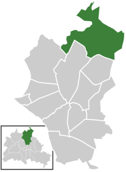
Buch is a German locality (Ortsteil) within the Berlin borough (Bezirk) of Pankow.
The village was founded in 1347, on Panke river, a tributary of Spree. Until 1920 Buch was a Brandenburger municipality merged in Berlin with the "Greater Berlin Act". From 1949 to 1990 it was part of East Berlin.
Located in north-eastern suburb of the city, Buch represents the northernmost locality of Berlin, with its northernmost point at the Rieselfelder, a former sewage farm transformed in a rural area part of the Bucher Forest (in Barnim Nature Park ). In this area it counts a lake named Bogensee.
In its large border with Brandenburg, Buch is surrounded by the municipalities of Wandlitz and Panketal (with the civil parishes of Zepernick, Röntgental and Neu Buch ), both in the district of Barnim. The Berliner localities bordering with Buch are Blankenfelde, Französisch Buchholz and Karow. In this Ortsteil it exist a zone named Stadtrandsiedlung Buch.
The locality is served by the urban rail line S2, part of the S-Bahn, at the station of Buch. It is also traversed, at its southern borders, by the Berliner beltway (A10, known as "Berliner Ring"). Nearest exit to Buch is the n.36, "Berlin-Weißensee".
...
Wikipedia


