Bergen (Landkreis Celle)
| Bergen | ||
|---|---|---|
|
||
| Coordinates: 52°48′37″N 9°57′40″E / 52.81028°N 9.96111°ECoordinates: 52°48′37″N 9°57′40″E / 52.81028°N 9.96111°E | ||
| Country | Germany | |
| State | Lower Saxony | |
| District | Celle | |
| Government | ||
| • Mayor | Rainer Prokop (CDU) | |
| Area | ||
| • Total | 163.77 km2 (63.23 sq mi) | |
| Elevation | 77 m (253 ft) | |
| Population (2015-12-31) | ||
| • Total | 13,027 | |
| • Density | 80/km2 (210/sq mi) | |
| Time zone | CET/CEST (UTC+1/+2) | |
| Postal codes | 29303 | |
| Dialling codes | 05051 | |
| Vehicle registration | CE | |
| Website | www.bergen-online.de | |
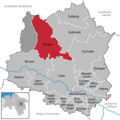
Bergen is a town in the north of Celle district on the Lüneburg Heath, in Lower Saxony, Germany. Administratively it acts as a municipal borough divided into 12 subordinate parishes based on the town and its surrounding villages: Becklingen, Belsen, Bergen, Bleckmar, Diesten, Dohnsen, Eversen, Hagen, Hassel, Offen, Sülze and Wardböhmen. Bergen-Belsen concentration camp was located in the area of Belsen.
The town had 13,099 inhabitants according to the census conducted in December 2008. Members of the British military and their families, who were not included in the census, brought the actual population to about 17,000. These soldiers occupied a NATO base and exercise on the Bergen-Hohne Training Area just outside the town, but the base closed in summer 2015 as part of the British Army's withdrawal from Germany. The Sieben Steinhäuser, a cluster of dolmens dating from the Stone Age, are located within the training area.
Bergen is located in the north of Celle district on the Lüneburg Heath, in Lower Saxony, Germany. The Bundesstraße 3 (B3) passed through the municipal territory from north to south.
Bergen is bordered by (from the north, clockwise): Wietzendorf (located in Heidekreis district), Südheide, Eschede, Celle, Winsen an der Aller and the unincorporated area Lohheide (all in Celle district).
...
Wikipedia


