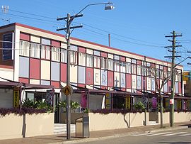
Berala, New South Wales
|
Berala Sydney, New South Wales |
|||||||||||||
|---|---|---|---|---|---|---|---|---|---|---|---|---|---|

Berala Hotel, Woodburn Road
|
|||||||||||||
| Population | 8,799 (2011 census) | ||||||||||||
| Postcode(s) | 2141 | ||||||||||||
| Location | 20 km (12 mi) west of Sydney CBD | ||||||||||||
| LGA(s) | Cumberland Council | ||||||||||||
| State electorate(s) | Auburn | ||||||||||||
| Federal Division(s) | Reid, Blaxland | ||||||||||||
|
|||||||||||||
Berala is a western suburb of Sydney, in the state of New South Wales, Australia, located 20 kilometres west of the central business district, in the local government area of Cumberland Council.
Berala is derived from Bareela, an Aboriginal word for a musk duck. The area was originally swampy and attracted wild birds. When the railway line was being extended from Lidcombe to Regents Park, the names Torrington, Sidmouth and Bareela were considered. The station opened in 1912, the public school in 1924 and the post office in 1927.
Berala railway station is on the Bankstown Line of the Sydney Trains network. Bus services run between Auburn and Bankstown.
A small group of shops is located beside the railway station, including a Charcoal Chicken, a newsagent, an adult bookstore and the EVT bakery. A Woolworths is located next to the train station.
According to the 2011 census, there were 8,799 residents in Berala. 39.3% of residents were born in Australia. The most common other countries of birth were China 12.8%, Vietnam 9.0% and Philippines 2.3%. 22.9% of residents spoke only English at home. Other languages spoken at home included Cantonese 16.7%, Mandarin 10.3% and Arabic 8.5%. The most common responses for religious affiliation were Catholic 22.0%, Islam 16.7% and Buddhism 16.0%.
...
Wikipedia
