Bennett Mountain
| Bennett Mountain | |
|---|---|

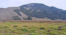
Bennett Mountain, viewed from Bennett Valley
|
|
| Highest point | |
| Elevation | 1,909 ft (582 m) NAVD 88 |
| Coordinates | 38°24′48″N 122°37′30″W / 38.413226469°N 122.624973647°WCoordinates: 38°24′48″N 122°37′30″W / 38.413226469°N 122.624973647°W |
| Geography | |
| Location | Sonoma County, California, U.S. |
| Parent range | Sonoma Mountains |
| Topo map | USGS Kenwood |
| Climbing | |
| Easiest route | Unpaved road |
Bennett Mountain, also commonly known as Bennett Peak, is a 1,909-foot (582 m) summit in the Sonoma Mountains of California. Located on the west edge of Annadel State Park, it separates Bennett Valley in the Russian River drainage basin from Sonoma Valley in the Sonoma Creek drainage basin.
Bennett Valley was named for James N. Bennett, an emigrant from Illinois who settled in the area in the 19th century.
Grapes were planted on Bennett Mountain as early as 1862, when Isaac DeTurk planted 30 acres (12 ha) at the base of its western slope. By 1878 he was producing 100,000 US gallons (380,000 l) of wine from his own and purchased grapes at a winery on Grange and Bennett Valley roads. Since 2003, the summit has formed the eastern edge of the Bennett Valley AVA.
...
Wikipedia
