Benicia–Martinez Bridge
| Benicia–Martinez Bridge | |
|---|---|

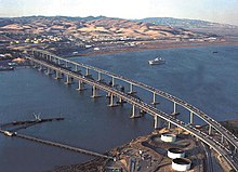
Aerial view of the Benicia–Martinez Bridge. From left to right: Southbound span (1962) Railway (1930) and Northbound span (2007)
|
|
| Coordinates | 38°02′26″N 122°07′23″W / 38.0406°N 122.1230°WCoordinates: 38°02′26″N 122°07′23″W / 38.0406°N 122.1230°W |
| Carries | 9 lanes of |
| Crosses | Carquinez Strait |
| Locale | Martinez and Benicia, California, U.S. |
| Official name | George Miller, Jr., Memorial Bridge (southbound span), Congressman George Miller Benicia–Martinez Bridge (northbound span) |
| Owner | Caltrans |
| Maintained by | Caltrans and the Bay Area Toll Authority |
| ID number | 28 0153 |
| Characteristics | |
| Design | Truss bridge (southbound span), segmental bridge (northbound span), Lift bridge (railroad bridge) |
| Total length | 1.7 miles (2.72 km, 8,976 feet) |
| Longest span | 528 feet (0.1 mi) (7 spans) |
| Clearance below | 138 feet (42.1 m) |
| History | |
| Opened | 1962/2007 |
| Statistics | |
| Toll | Cars (northbound only) $5.00 (cash or FasTrak), $2.50 (carpools during peak hours, FasTrak only) |
The Benicia–Martinez Bridge refers to three parallel bridges which cross the Carquinez Strait just west of Suisun Bay; the spans link Benicia, California on the north side with Martinez, California on the south.
The original 1.2-mile (1.9 km) deck truss bridge opened in 1962 to replace the last automotive ferry service in the San Francisco Bay Area. The 1962 bridge has seven 528-foot (161 m) spans and 138 feet (42 m) of vertical clearance, now carrying four lanes of southbound traffic, as well as a path for pedestrians and bicyclists. It was named the George Miller, Jr., Memorial Bridge in 1975 after George Miller, Jr. A 1.7-mile (2.7 km) bridge was built alongside and opened on August 25, 2007 with five lanes of northbound traffic. In 2007, it was named the Congressman George Miller Benicia–Martinez Bridge after George Miller, Miller Jr.'s son. The cost of the 1962 span was US$25 million and US$1.3 billion for the 2007 span. The bridge is part of Interstate 680, major transportation link, and connects other heavily traveled freeways.
Between the two vehicle bridges is a Union Pacific Railroad bridge, the first bridge at this location, built between April 1929 and October 1930 by Southern Pacific. It is used by Union Pacific and BNSF (trackage rights) freight trains and 36 scheduled Amtrak passenger trains each weekday. Passenger trains include the long-distance trains California Zephyr and Coast Starlight and short-haul Capitol Corridor trains.
...
Wikipedia
