Benham, Kentucky
| Benham, Kentucky | |
|---|---|
| City | |

Benham City Hall
|
|
| Nickname(s): The Little Town That International Harvester, Coal Miners, and Their Families Built | |
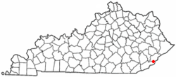
 Location of Benham within Kentucky |
|
| Coordinates: 36°57′53″N 82°57′13″W / 36.96472°N 82.95361°WCoordinates: 36°57′53″N 82°57′13″W / 36.96472°N 82.95361°W | |
| Country | United States |
| State | Kentucky |
| County | Harlan |
| Incorporated | March 7, 1961 |
| Government | |
| • Mayor | John T. Dodd |
| Area | |
| • Total | 0.4 sq mi (1.0 km2) |
| • Land | 0.4 sq mi (1.0 km2) |
| • Water | 0.0 sq mi (0.0 km2) |
| Elevation | 1,591 ft (485 m) |
| Population (2010) | |
| • Total | 500 |
| • Density | 1,268.1/sq mi (495.0/km2) |
| Time zone | EST (UTC-5) |
| • Summer (DST) | EDT (UTC-4) |
| ZIP code | 40807 |
| Area code(s) | 606 |
| FIPS code | 21-05662 |
| GNIS feature ID | 0486849 |
| Website | www.benhamky.org |
Benham is a home rule-class city in Harlan County, Kentucky, in the United States. The city was formally incorporated by the General Assembly in 1961. The population was 500 at the 2010 census.
Benham is located at 36°57′53″N 82°57′15″W / 36.96472°N 82.95417°W (36.964832, -82.954035).
According to the United States Census Bureau, the city has a total area of 0.4 square miles (1.0 km2), all of it land.
As of the census of 2000, there were 599 people, 248 households, and 181 families residing in the city. The population density was 1,519.2 people per square mile (593.0/km²). There were 288 housing units at an average density of 730.4 per square mile (285.1/km²). The racial makeup of the city was 88.81% White, 9.85% African American, 0.33% Native American, 0.17% Asian, 0.33% from other races, and 0.50% from two or more races. Hispanic or Latino of any race were 0.50% of the population.
...
Wikipedia
