Belle-Rivière, Quebec
| Belle-Rivière | |
|---|---|
| Unorganized territory | |
 |
|
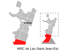
| Location in Saguenay–Lac-Saint-Jean Quebec. | |
| Coordinates: 48°10′N 71°46′W / 48.167°N 71.767°WCoordinates: 48°10′N 71°46′W / 48.167°N 71.767°W | |
| Country |
|
| Province |
|
| Region | Saguenay–Lac-Saint-Jean |
| RCM | Lac-Saint-Jean-Est |
| Constituted | unspecified |
| Government | |
| • Federal riding | Roberval—Lac-Saint-Jean |
| • Prov. riding | Lac-Saint-Jean |
| Area | |
| • Total | 646.60 km2 (249.65 sq mi) |
| • Land | 610.30 km2 (235.64 sq mi) |
| Population (2011) | |
| • Total | 0 |
| • Density | 0.0/km2 (0/sq mi) |
| • Pop 2006-2011 |
|
| • Dwellings | 1 |
| Time zone | EST (UTC-5) |
| • Summer (DST) | EDT (UTC-4) |
| Highways |
|
Belle-Rivière is an unorganized territory in the Canadian province of Quebec, located in the regional county municipality of Lac-Saint-Jean-Est. It had a population of zero in the Canada 2006 Census, and covered a land area of 610.30 km2. The Métabetchouane River forms its western boundary.
The territory is named after la Belle Rivière ("the beautiful river") that has its source at Lac de la Belle Rivière ("Beautiful River Lake") that is also within the territory. The river was historically an important route for the natives and explorers of the Lac Saint-Jean region.
...
Wikipedia

