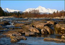
Belá River
| Belá | |
|---|---|
 |
|
| Basin features | |
| Main source | High Tatra |
| River mouth |
Váh in Liptovský Hrádok 49°02′06″N 19°42′36″E / 49.0349°N 19.7101°ECoordinates: 49°02′06″N 19°42′36″E / 49.0349°N 19.7101°E |
| Progression | Váh→ Danube→ Black Sea |
| Physical characteristics | |
| Length | 22 km (14 mi) |
The Belá (Hungarian: Béla-patak), 22 kilometres (14 mi) in length, is a mountainous stream draining the headwaters of the Váh River basin in Tatra National Park, northern Slovakia. It is a right tributary, into which it flows at the town of Liptovský Hrádok. The Belá itself is formed by two tributaries, the streams Tichý potok and Kôprovský potok, whose sources are in the High Tatra mountains, and which have their confluence near Podbanské, part of the town of Vysoké Tatry.
The Belá is well suited to rafting and kayaking.
...
Wikipedia
