Bejucal
| Bejucal | |
|---|---|
| Municipality | |

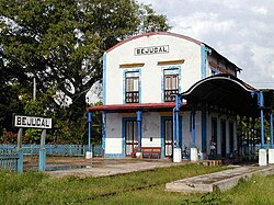
Bejucal railway station
|
|
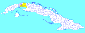
 Bejucal municipality (red) within Mayabeque Province (yellow) and Cuba |
|
| Location of Bejucal in Cuba | |
| Coordinates: 22°55′58″N 82°23′13″W / 22.93278°N 82.38694°WCoordinates: 22°55′58″N 82°23′13″W / 22.93278°N 82.38694°W | |
| Country |
|
| Province | Mayabeque |
| Founded | 1874 |
| Area | |
| • Total | 120 km2 (50 sq mi) |
| Elevation | 105 m (344 ft) |
| Population (2004) | |
| • Total | 25,425 |
| • Density | 211.9/km2 (549/sq mi) |
| Time zone | EST (UTC-5) |
| Area code(s) | +53-7 |
Bejucal is a municipality and town in the Mayabeque Province of Cuba. It was founded in 1874. It is well known as the terminal station of the first railroad built in Cuba and Latin America in 1831. It also hosts one of the most popular and traditional carnival fest in Cuba: "Charangas de Bejucal".
The municipality borders to the north with Boyeros (a municipal borough of Havana); to the east with San José de las Lajas; to the south with Quivicán; and on the west with San Antonio de los Baños.
It is divided into the barrios of Bejucal, Beltrán, Cuatro Caminos, Rancho Recreo, Buenaventura, Caguazo and Río Hondo.
In 2004, the municipality of Bejucal had a population of 25,425. With a total area of 120 km2 (46 sq mi), it has a population density of 211.9/km2 (549/sq mi).
Notable current and former residents of Bejucal include:
...
Wikipedia

