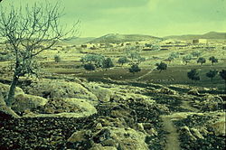
Beit Ur al-Tahta
| Beit Ur al-Tahta | |
|---|---|
| Other transcription(s) | |
| • Arabic | بيت عور التحت |
| • Also spelled | Bayt Ur at-Tahta (unofficial) |

Beit Ur al-Tahta, between 1950 and 1977.
|
|
| Location of Beit Ur al-Tahta within the Palestinian territories | |
| Coordinates: 31°53′42″N 35°05′01″E / 31.89500°N 35.08361°ECoordinates: 31°53′42″N 35°05′01″E / 31.89500°N 35.08361°E | |
| Palestine grid | 158/144 |
| Governorate | Ramallah & al-Bireh |
| Government | |
| • Type | Municipality |
| Population (2007) | |
| • Jurisdiction | 4,372 |
| Name meaning | "Lower house of Ur" |
Beit Ur al-Tahta (Arabic: بيت عور التحتى, lit. "Lower house of straw") is a Palestinian village located in the Seam Zone in the central West Bank, in the Ramallah and Al-Bireh Governorate. The village is located on the site of the biblical Bethoron, on a hilltop facing Beit Ur al-Foqa. According to the Palestinian Central Bureau of Statistics Beit Ur at-Tahta had a population of 4,372 inhabitants in mid-2007.
In January 2001, a burial cave was discovered on the southern outskirts of the village. The cave consisted of two chambers and an arched doorway. Artifacts inside the cave included several pottery fragments, a cooking pot, a bowl and goblet dating to the end of the Second Temple period (1st century BCE–1st century CE).
To the west of the village is the ruins of a chapel, apparently from the Byzantine period, and ceramics from the same period have also been found. The place was mentioned in the 12th century as a fief of the Holy Sepulchre.
In 1596 the village appeared in Ottoman tax registers under the name of Bayt 'Ur as-Sufla and was part of the Nahiya ("Subdistrict") of Quds of the Liwa ("District") of Quds. It had a population of 20 Muslim households and paid taxes on wheat, barley, olives, goats and/or beehives.
A 19th-century traveler visiting the town found the remains of ancient foundations, rock-cut cisterns and a tomb that was said to have contained treasures. Father P.M. Séjourné, revisiting the site, noticed the ruins of a large church: "The mosaic pavement of an important church located northeast of the village has disappeared, at least for the moment, under a watermelon field. The scattered spoils of the Christian building have enriched the neighbouring modern mosque and many hovels nearby. Fragments of a graceful frieze, capitals with Corinthian acanthus carved in white marble, columns and dressed stones lie unused along the roads." Another researcher, Victor Guérin, saw two columns from the church inside the local mosque. Based on these finds, it was concluded that the village was once Christian, and had a large three-nave church.
...
Wikipedia

