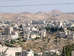
Beit Sahour
| Beit Sahour | ||
|---|---|---|
| Other transcription(s) | ||
| • Arabic | بيت ساحور | |
| • Also spelled | Beit Sahur (official) Bayt Sahoor (unofficial) |
|

View of Beit Sahour
|
||
|
||
| Location of Beit Sahour within the Palestinian territories | ||
| Coordinates: 31°42′N 35°13′E / 31.700°N 35.217°ECoordinates: 31°42′N 35°13′E / 31.700°N 35.217°E | ||
| Governorate | Bethlehem | |
| Government | ||
| • Type | Municipality | |
| • Head of Municipality | Hani al-Hayek | |
| Area | ||
| • Jurisdiction | 6,945 dunams (6.9 km2 or 2.7 sq mi) | |
| Population (2007) | ||
| • Jurisdiction | 12,367 | |
| Name meaning | "House of the magicians" | |
| Website | Beit Sahour Municipality | |
Beit Sahour (Arabic: بيت ساحور pronounced ![]() Bayt Saahoor ) is a Palestinian town east of Bethlehem under the administration of the Palestinian National Authority. The population of 12,367 is 80% Christian (most of them Greek Orthodox) and 20% Muslim.
Bayt Saahoor ) is a Palestinian town east of Bethlehem under the administration of the Palestinian National Authority. The population of 12,367 is 80% Christian (most of them Greek Orthodox) and 20% Muslim.
There are two enclosures in the eastern part of Beit Sahour that are claimed by different Christian denominations to be the actual 'Shepherds Field': one belonging to the Greek Orthodox Church and the other, the Catholic site, to the Franciscan Custody of the Holy Land.
The name Beit Sahur belongs to two places in the vicinity: Beit Sahur al-Atiqah ("ancient Beit Sahur") and Beit Sahur an-Nasara ("Beit Sahur of the Christians").
Beit Sahur al-Atiqah (Palestine grid 171/123) surrounded the tomb of Sheikh Ahmad al-Sahuri, a local saint to whom the local Arab tribe of al-Sawahirah attribute their name. The Sawahirah originate from the Hejaz and entered Palestine through al-Karak.Mujir al-Din mentions this place in a biography of a Muslim scholar Sha'ban bin Salim bin Sha'ban, who died in Beit Sahur al-Atiqah in 1483 at the age of 105.
...
Wikipedia


