Beccaria Township, Clearfield County, Pennsylvania
| Beccaria Township, Pennsylvania | |
|---|---|
| Township | |

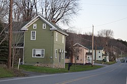
Along Pennsylvania Route 53 at Blain City
|
|
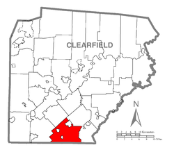
 Map of Clearfield County, Pennsylvania highlighting Beccaria Township |
|
 Map of Clearfield County, Pennsylvania |
|
| Country | United States |
| State | Pennsylvania |
| County | Clearfield |
| Settled | 1798 |
| Incorporated | 1807 |
| Area | |
| • Total | 36.0 sq mi (93.2 km2) |
| • Land | 35.8 sq mi (92.6 km2) |
| • Water | 0.2 sq mi (0.6 km2) |
| Population (2010) | |
| • Total | 1,782 |
| • Density | 50/sq mi (19.2/km2) |
| Time zone | Eastern (EST) (UTC-5) |
| • Summer (DST) | EDT (UTC-4) |
| Area code(s) | 814 |
Beccaria Township is a township in Clearfield County, Pennsylvania, United States. The population was 1,782 at the 2010 census. It is named in honor of Cesare Beccaria, an Enlightenment thinker.
The township is located in southern Clearfield County and is bordered by Cambria County to the south. According to the United States Census Bureau, the township has a total area of 36.0 square miles (93.2 km2), of which 35.8 square miles (92.6 km2) is land and 0.23 square miles (0.6 km2), or 0.64%, is water.Clearfield Creek, a tributary of the West Branch Susquehanna River, crosses the township from south to north.
The township surrounds two boroughs, Irvona and Coalport, and borders the borough of Glen Hope on three sides. The boroughs are separate municipalities from the township. Unincorporated communities within the township include:
As of the census of 2000, there were 1,835 people, 747 households, and 539 families residing in the township. The population density was 50.5 people per square mile (19.5/km²). There were 873 housing units at an average density of 24.0/sq mi (9.3/km²). The racial makeup of the township was 99.51% White, 0.05% African American, 0.11% Native American, and 0.33% from two or more races. Hispanic or Latino of any race were 0.16% of the population.
...
Wikipedia
