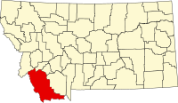
Beaverhead
| Beaverhead County, Montana | |
|---|---|

|
|
 Location in the U.S. state of Montana |
|
 Montana's location in the U.S. |
|
| Founded | 1865 |
| Seat | Dillon |
| Largest city | Dillon |
| Area | |
| • Total | 5,572 sq mi (14,431 km2) |
| • Land | 5,542 sq mi (14,354 km2) |
| • Water | 30 sq mi (78 km2), 0.5% |
| Population (est.) | |
| • (2016) | 9,401 |
| • Density | 1.7/sq mi (1/km²) |
| Congressional district | At-large |
| Time zone | Mountain: UTC-7/-6 |
| Website | www |
Beaverhead County is the largest county by area in the U.S. state of Montana. As of the 2010 census, the population was 9,246. Its county seat is Dillon. The county was founded in 1865.
Much of the perimeter of the county is the Continental Divide, including all of its border with the state of Idaho. The divide heads east into Montana at the county border with Ravalli County, between Lost Trail Pass and Chief Joseph Pass.
The county name is derived from a rock formation, which the Shoshone described as being shaped like a beaver's head.
The original county seat was the gold-mining town of Bannack. In 1881 it was moved to Dillon.
According to the U.S. Census Bureau, the county has a total area of 5,572 square miles (14,430 km2), of which 5,542 square miles (14,350 km2) is land and 30 square miles (78 km2) (0.3%) is water. It is the largest county in Montana by area.
The Big Hole River runs through the county.
As of the census of 2000, there were 9,202 people, 3,684 households, and 2,354 families residing in the county. The population density was 2 people per square mile (1/km²). There were 4,571 housing units at an average density of 1 per square mile (0/km²). The racial makeup of the county was 95.86% White, 0.18% Black or African American, 1.46% Native American, 0.18% Asian, 0.04% Pacific Islander, 1.09% from other races, and 1.18% from two or more races. 2.67% of the population were Hispanic or Latino of any race. 16.7% were of German, 14.9% English, 10.7% Irish, 9.0% American and 7.2% Norwegian ancestry.
...
Wikipedia
