Beach Haven, New Zealand
| Beach Haven | |
|---|---|

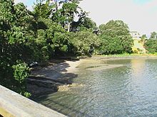
View of the beach at Beach Haven from Beach Haven Wharf
|
|
| Basic information | |
| Local authority | Auckland Council |
| Electoral ward | North Shore |
| Date established | 1922 |
| Population | 10,137 (2013) |
| Facilities | |
| Ferry terminal(s) | (Beach Haven Wharf) |
| Hospitals(s) | (Beach Haven Hospice) |
| Surrounds | |
| North | (Waitemata Harbour), Greenhithe |
| Northeast | Bayview |
| East | Windy Ridge |
| Southeast | Birkdale |
| South | Birkdale |
| Southwest | (Waitemata Harbour) |
| West | (Waitemata Harbour), Hobsonville |
| Northwest | (Waitemata Harbour), Greenhithe |
Beach Haven is a suburb of Auckland, New Zealand and is located north-west from the city's CBD. It has 3492 households and 10,137 residents. The area has gentrified rapidly over recent years as young professionals move into the area.
Prior to European settlement, the Beach Haven area was covered to the water’s edge by thick bush, pohutukawa, ferns and giant kauri trees. Maori tribes inhabited the area, but were decimated by wars and finally succumbed to the newly acquired guns of Hongi Hika. In 1844 the area was sold to the Government and became deserted. One of the first settlers in the district established an orchard near Soldier’s Bay and as the kauri trees were gradually removed from the land, it was found to be an ideal place for fruit growing, especially grapes and strawberries. Most of the kauri trees taken out were used by boat builders for masts and spurs.
The first European settlers arrived in the 1860s and by the 1880s the area was a popular summer resort, with many city dwellers making the trip across the harbour to Island Bay for excursions and holidays.
Up until the 1920s the area was rural, largely made up of market gardens growing fruit (mostly strawberries) and vegetables for the growing city across the harbour. Most of this produce was transported by water. There were also sawmills in the area, the evidence of which could be seen for decades in the form of abandoned machinery and mounds of sawdust. The area was always popular as a holiday destination, evidence of which can still be seen today in some of the remaining baches.
In 1923, the Birkdale Land Company bought and surveyed the land around where the wharf is now and it was then marketed as the Beach Haven Estate, "the Gem of the Waitemata."
After the construction of the Harbour Bridge in 1959, housing subdivisions completed the transformation into an urban area.
Beach Haven forms part of the North Shore Ward and Kaipatiki Local Board under the Auckland Council. Prior to 2010, the area had been administered as part of the Birkenhead Borough Council and then as part of North Shore City Council.
Under the voting district for elections to the Parliament of New Zealand it forms part of the Northcote electorate.
Beach Haven has one main shopping area with a variety of shops, including a French cafe, two bakeries, a post office, a gym and a police community constable office. There are several preschools and one primary school that serve the area. Churches in the area include the Anglican, Catholic, Orthodox, Mormon and Assembly Of God.
Beach Haven is surrounded by many beaches which are suitable for swimming, including Charcoal Bay which is considered one of the most beautiful bays in the Waitemata Harbour. The area also has a wharf which is a very popular feature of Beach Haven. The biggest park in Beach Haven is Shepherd's Park which has a 1.6 km walk through native bush beside Oruamo/Hellyers Creek, as well as squash, bowling and tennis facilities. It also has rugby and soccer grounds and is home to Birkenhead United AFC.
...
Wikipedia
