Bay Circuit Trail
| Bay Circuit Trail | |
|---|---|

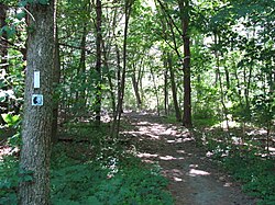
At Monument Street in Concord
|
|
| Length | 200 mi (322 km) |
| Location | Plymouth County, Middlesex County, eastern Worcester County, Bristol County and Essex County, Massachusetts |
| Use | Primarily hiking. |
| Elevation | |
| Highest point | Nobscot Hill, Framingham, Massachusetts, 602 ft (183 m) |
| Lowest point | Sea level, north and south terminus |
| Hiking details | |
| Trail difficulty | easy with some moderately difficult sections |
| Season | year round (may be ice or snow in winter) |
| Hazards | deer ticks, poison ivy, road crossings |
Coordinates: 42°37′40.23″N 71°4′6.32″W / 42.6278417°N 71.0684222°W
The Bay Circuit Trail and Greenway or Bay Circuit is a Massachusetts recreational trail and greenway connecting the outlying suburbs of Boston from Plum Island in Newburyport to Kingston Bay in Duxbury, a distance of 200 miles (320 km).
Landmarks include Henry David Thoreau's Walden Pond, Great Meadows National Wildlife Refuge, the Charles River, Massachusetts Audubon's Moose Hill Wildlife Sanctuary, Minute Man National Historical Park, Lowell National Historic Park, the Merrimack River, and Plum Island.
The Bay Circuit Trail connects to other long distance recreation trails, such as the Warner Trail. The Minuteman Bikeway will provide a connection to downtown Boston when the Somerville Community Path is completed. The East Coast Greenway will also connect downtown if it is completed as envisioned.
...
Wikipedia
