Batura
| Batura Muztagh | |
|---|---|

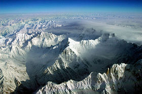
Aerial view of part of the Batura Muztagh from the southeast
|
|
| Highest point | |
| Peak | Batura Sar |
| Elevation | 7,795 m (25,574 ft) |
| Coordinates | 36°30′36″N 74°31′37″E / 36.51000°N 74.52694°ECoordinates: 36°30′36″N 74°31′37″E / 36.51000°N 74.52694°E |
| Geography | |
| Country | Pakistan |
| State/Province | Gilgit District |
| Parent range | Karakoram |
The Batura Muztagh mountains are a sub-range of the Karakoram mountain range. They are located west of the Hunza Valley in the Gilgit District of the Gilgit-Baltistan province in northern Pakistan.
They are the westernmost sub-range of the Karakoram, running from Chalt village in Bar Valley in the east to Kampir Dior in the Kurumbar Valley in the west, and they separate the Pamir and Hindu Kush ranges from the Karakoram range.
...
Wikipedia
