Batthyaneum Library
| Alba Iulia | |||
|---|---|---|---|
| County capital | |||
 |
|||
|
|||
| Location of Alba Iulia | |||
| Coordinates: 46°4′1″N 23°34′12″E / 46.06694°N 23.57000°ECoordinates: 46°4′1″N 23°34′12″E / 46.06694°N 23.57000°E | |||
| Country |
|
||
| County | Alba County | ||
| Status | County capital | ||
| Government | |||
| • Mayor | Mircea Hava (Democratic Liberal Party) | ||
| Area | |||
| • Total | 103.65 km2 (40.02 sq mi) | ||
| Population (2011) | |||
| • Total | 63,536 | ||
| Time zone | EET (UTC+2) | ||
| • Summer (DST) | EEST (UTC+3) | ||
| Website | http://www.apulum.ro/ | ||
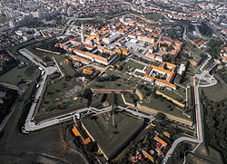
Alba Iulia (Romanian pronunciation: [ˌalba ˈjuli.a]; German: Karlsburg or Carlsburg, formerly Weißenburg, Hungarian: Gyulafehérvár, Latin: Apulum,Ottoman Turkish: Erdel Belgradı or Belgrad-ı Erdel) is a city located on the Mureş River in Alba County, Transylvania, Romania, with a population of 63,536 as of 2011[update][update]. Since the High Middle Ages, the city has been the seat of Transylvania's Roman Catholic diocese. Between 1541 and 1690 it was the capital of the Eastern Hungarian Kingdom and the latter Principality of Transylvania. Alba Iulia is historically important for Romanians, Hungarians and Transylvanian Saxons.
The city administers four villages: Bărăbanț (Borbánd), Micești (Ompolykisfalud), Oarda (Alsóváradja) and Pâclișa (Poklos).
During the Roman period the settlement was called Apulum (from the Dacian Apoulon, mentioned by Ptolemy). When the settlement – upon Roman ruins – became the seat of a dukedom in the 10th century, the population may have been Slavic. The early Slavic name of the settlement was Bălgrad (meaning "white castle" or "white town"). The old Romanian name of the town was Bălgrad, originated from Slavic.
...
Wikipedia


