Bathurst Region
|
Bathurst Region New South Wales |
|||||||||||||||
|---|---|---|---|---|---|---|---|---|---|---|---|---|---|---|---|

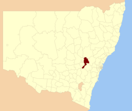
Location in New South Wales
|
|||||||||||||||
| Coordinates | 33°25′S 149°34′E / 33.417°S 149.567°ECoordinates: 33°25′S 149°34′E / 33.417°S 149.567°E | ||||||||||||||
| Population | 42,231 (2015 est) | ||||||||||||||
| • Density | 11.055/km2 (28.63/sq mi) | ||||||||||||||
| Established | 2004 | ||||||||||||||
| Area | 3,820 km2 (1,474.9 sq mi) | ||||||||||||||
| Mayor | Gary Rush (Independent) | ||||||||||||||
| Council seat | Bathurst | ||||||||||||||
| Region | Central West | ||||||||||||||
| State electorate(s) | Bathurst | ||||||||||||||
| Federal Division(s) | Calare | ||||||||||||||
 |
|||||||||||||||
| Website | Bathurst Region | ||||||||||||||
|
|||||||||||||||
The Bathurst Region is a local government area in the Central West region of New South Wales, Australia. The area is located adjacent to the Great Western Highway, Mid-Western Highway, Mitchell Highway and the Main Western railway line. At the 2011 census, the Bathurst Region had a population of 38,519.
The administrative centre of the area is located in the city of Bathurst, approximately 200 kilometres (120 mi) west of Sydney central business district.
The Mayor of Bathurst is Cr. Gary Rush, an independent politician.
In addition to the city of Bathurst, the area includes the suburbs of Kelso and Raglan and the villages of Eglinton, Perthville, Rockley, Georges Plains, Trunkey Creek, Brewongle, Vittoria, Peel, Wattle Flat, Sofala, Hill End, Meadow Flat and Sallys Flat.
...
Wikipedia
