Bathford
| Bathford | |
|---|---|
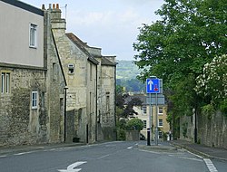
 High Street |
|
| Bathford shown within Somerset | |
| Population | 1,759 |
| OS grid reference | ST793666 |
| Unitary authority | |
| Ceremonial county | |
| Region | |
| Country | England |
| Sovereign state | United Kingdom |
| Post town | BATH |
| Postcode district | BA1 |
| Dialling code | 01225 |
| Police | Avon and Somerset |
| Fire | Avon |
| Ambulance | South Western |
| EU Parliament | South West England |
| UK Parliament | |
Bathford (pronounced with the emphasis on the second syllable) is a village and civil parish 3 miles (4.8 km) east of Bath, England. The parish, which includes Warleigh, has a population of 1,759 and extends over 1,800 acres (7.3 km2).
The ancient charter Codex Diplomaticus Aevi Saxonici describes a manor parish consisting of three tithings or quasi manors: Bathford in the centre, Shockerwick to the north, and Warley [Warleigh] to the south. This corresponds closely to the current boundaries. This manor was known as Forde up until the seventeenth century; the name was derived from the ford that crosses the By Brook, connecting Bathford to neighbouring Bathampton.
Near the river crossing is the site of a Roman villa, the hypocaust of which was found about the middle of the seventeenth century. This villa is described in John Aubrey's Monumenta Britannica:
The ford from which the village derived its name was connected with the Fosse Way. This is mentioned in a Saxon charter of the tenth century relating to the manor. The Fosse Way stills forms the boundary of the parish.
Bathford was part of the hundred of Bath Forum.
The old Bathford railway bridge was built by Isambard Kingdom Brunel as part of the Great Western Railway. A station called Bathford Halt closed in 1965.
Near Bathford, on the opposite side of the river, is a large meadow known as Horselands where, according to tradition, the Roman cavalry were exercised. More recently, the area bounded by Ostlings Lane and the Bradford Road (A363) was used to keep the spare horses used to haul the mail coaches up Bathford Hill. They then returned to the field to await the next coach. Some older long-standing residents of Bathford still refer to Ostlings Lane as Horses Lane. Whether the two areas are related is somewhat uncertain.
...
Wikipedia

