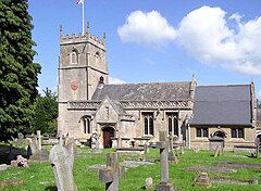
Bathampton
| Bathampton | |
|---|---|
 Church of St Nicholas |
|
| Bathampton shown within Somerset | |
| Population | 1,603 |
| OS grid reference | ST777662 |
| Unitary authority | |
| Ceremonial county | |
| Region | |
| Country | England |
| Sovereign state | United Kingdom |
| Post town | BATH |
| Postcode district | BA |
| Dialling code | 01225 |
| Police | Avon and Somerset |
| Fire | Avon |
| Ambulance | South Western |
| EU Parliament | South West England |
| UK Parliament | |
Bathampton (/ˌbɑːθˈæmptən/) is a village and civil parish 2 miles (3 km) east of Bath, England on the south bank of the River Avon. The parish has a population of 1,603.
The Kennet and Avon Canal passes through the village and a toll bridge links Bathampton to Batheaston on the north bank of the canal.
Bathampton Camp is a univallate Iron Age hill fort situated approximately 2 miles (3.2 km) east from the village. The site was excavated in 1904–05 and in 1952–54. Results found human and animal remains, pottery and flint flakes.
The parish was part of the hundred of Hampton.
The village used to be served by Bathampton railway station, but it was closed following the destructive Beeching Axe.
Plasticine was manufactured in the village between 1900 and 1983 by a company founded by William Harbutt, who also lived in Bathampton.
...
Wikipedia

