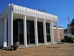
Batesville, Mississippi
| Batesville, Mississippi | |
|---|---|
| City | |

Panola County Courthouse in Batesville
|
|
 Location of Batesville, Mississippi |
|
| Location in the United States | |
| Coordinates: 34°19′4″N 89°56′33″W / 34.31778°N 89.94250°WCoordinates: 34°19′4″N 89°56′33″W / 34.31778°N 89.94250°W | |
| Country | United States |
| State | Mississippi |
| County | Panola |
| Government | |
| • Type | Mayor-Counsel |
| • Mayor | Jerry Autrey (Democratic Party) |
| • Alderman-at-Large/Vice Mayor | Teddy Morrow |
| • Ward 1 Alderman | Bill Duggar |
| • Ward 2 Alderman | Ted Stewart |
| • Ward 3 Alderman | Stan Harrison |
| Area | |
| • Total | 11.1 sq mi (28.9 km2) |
| • Land | 11.1 sq mi (28.9 km2) |
| • Water | 0.0 sq mi (0.0 km2) |
| Elevation | 233 ft (71 m) |
| Population (2010) | |
| • Total | 7,463 |
| • Density | 670/sq mi (260/km2) |
| Time zone | Central (CST) (UTC-6) |
| • Summer (DST) | CDT (UTC-5) |
| ZIP code | 38606 |
| Area code(s) | 662 |
| FIPS code | 28-03620 |
| GNIS feature ID | 0666568 |
| Website | City website |
Batesville is a city in Panola County, Mississippi. The population was 7,463 at the 2010 census.
Batesville is one of two county seats which the legislature established for Panola County, related to a longstanding rivalry between towns on either side of the Tallahatchie River; the other is Sardis, located north of the river.
Batesville was founded in the 1850s following the construction of the Mississippi and Tennessee Railroad.
According to the United States Census Bureau, the city has a total area of 11.1 square miles (29 km2), all land.
As of the census of 2000, there were 7,113 people, 2,577 households, and 1,821 families residing in the city. The population density was 638.2 people per square mile (246.3/km²). There were 2,791 housing units at an average density of 250.4 per square mile (96.6/km²). The racial makeup of the city was 56.43% White, 41.88% African American, 0.06% Native American, 0.38% Asian, 0.04% Pacific Islander, 0.82% from other races, and 0.39% from two or more races. Hispanic or Latino of any race were 1.60% of the population.
There were 2,577 households out of which 35.7% had children under the age of 18 living with them, 44.7% were married couples living together, 21.5% had a female householder with no husband present, and 29.3% were non-families. 26.2% of all households were made up of individuals and 12.6% had someone living alone who was 65 years of age or older. The average household size was 2.59 and the average family size was 3.14.
...
Wikipedia

