Basurto-Zorrotza
| Basurto-Zorroza | |
|---|---|
| District | |

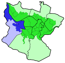
Basurto-Zorroza district is highlighted in blue in this map of the districts of Bilbao.
|
|
| Country | Spain |
| Autonomous community | Basque Country |
| Province | Biscay |
| Comarca | Greater Bilbao |
| Municipality | Bilbao |
| Area | |
| • Total | 7.09 km2 (2.74 sq mi) |
| Population (2016) | |
| • Total | 31,672 |
| • Density | 4,500/km2 (12,000/sq mi) |
Basurto-Zorroza (or Basurtu-Zorrotza) is the eighth district of the city of Bilbao (Biscay), in the Spanish Basque Country. It is divided into the neighbourhoods of Altamira, Basurto, Olabeaga, Masustegui-Monte Caramelo and Zorrotza. It is separated from Barakaldo by the river Kadagua. Its area is 7.09 square kilometers and has a population of 31,672 inhabitants.
The district is the location of:
The 8th district of Bilbao has a very important role as a transportation hub, the main road access to the city from the A-8 motorway crosses the heart of the district (Av. Sabino Arana). This causes heavy disruption to the residents of the district, a new road access is projected through the less populated areas of Basurto.
All railway companies operating in Bilbao except EuskoTren have stations in the 8th district:
On top of that, the main bus station of the city (Termibus) is located in Basurto.
Coordinates: 43°16′05″N 2°57′56″W / 43.26806°N 2.96556°W
...
Wikipedia
