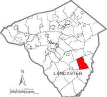
Bart Township, Lancaster County, Pennsylvania
| Bart Township, Pennsylvania | |
|---|---|
| Township | |

Jackson's Sawmill Covered Bridge in Bart Township
|
|
 Map of Lancaster County, Pennsylvania highlighting Bart Township |
|
 Map of Lancaster County, Pennsylvania |
|
| Country | United States |
| State | Pennsylvania |
| County | Lancaster |
| Incorporated | 1744 |
| Government | |
| • Type | Board of Supervisors |
| Area | |
| • Total | 16.2 sq mi (42 km2) |
| Population (2010) | |
| • Total | 3,094 |
| • Density | 185.3/sq mi (71.5/km2) |
| Time zone | Eastern (EST) (UTC-5) |
| • Summer (DST) | EDT (UTC-4) |
| Area code(s) | 717 |
Bart Township is a township in southeastern Lancaster County, Pennsylvania, United States. At the 2010 Census the population was 3,094.
The name of Bart Township apparently comes from a reinterpretation of the abbreviation "Bart." for "Baronet". This abbreviation was used by former Colonial Governor Sir William Keith, Bart. After being forced out of the Governorship by Hannah Penn, Sir William Keith, Bart. won election as an Assemblyman in Philadelphia. In March 1728, Sir William Keith, Bart. left Pennsylvania in a hurry—he was running out on his debts. He left for England, never to return He abandoned his wife, Lady Keith, who is buried in Christ Church Cemetery in Philadelphia.
What is now Bart Township was part of Sadsbury, Chester County before the formation of Lancaster County.
In 1744, Sadsbury Township was split into two; the western part was organized as Bart Township and the eastern part remained Sadsbury Township. In 1854, Bart Township was split into two, with the western part organized as Eden Township, and the eastern part remaining Bart Township.
On October 2, 2006, a lone gunman, identified as Charles Carl Roberts IV, shot ten Amish schoolgirls, killing five of them, in an attack on West Nickel Mines Parochial School, an Amish one-room school in Nickel Mines, Bart Township. Roberts then shot and killed himself as police responded.
According to the U.S. Census Bureau, the township has a total area of 16.2 square miles (42 km2), all of it land.
As of the census of 2000, there were 3,003 people, 820 households, and 700 families residing in the township. The population density was 185.3 people per square mile (71.5/km²). There were 836 housing units at an average density of 51.6/sq mi (19.9/km²). The racial makeup of the township was 98.60% White, 0.80% Black or African American, 0.27% Native American, 0.17% from other races, and 0.17% from two or more races. 0.13% of the population were Hispanic or Latino of any race.
...
Wikipedia
