Barnegat Light, New Jersey
| Barnegat Light, New Jersey | |
|---|---|
| Borough | |
| Borough of Barnegat Light | |
 Map of Barnegat Light in Ocean County. Inset: Location of Ocean County highlighted in the State of New Jersey. |
|
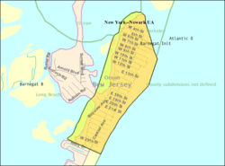
 Census Bureau map of Barnegat Light, New Jersey |
|
| Coordinates: 39°45′07″N 74°06′39″W / 39.752007°N 74.110893°WCoordinates: 39°45′07″N 74°06′39″W / 39.752007°N 74.110893°W | |
| Country | |
| State |
|
| County | Ocean |
| Incorporated | March 29, 1904 as Barnegat City |
| Renamed | November 2, 1948 as Barnegat Light |
| Named for | Dutch language "breaker's inlet" |
| Government | |
| • Type | Borough |
| • Body | Borough Council |
| • Mayor | Kirk O. Larson Sr. (R, term ends December 31, 2018) |
| • Administrator / Clerk | Brenda L. Kuhn (acting) |
| Area | |
| • Total | 0.852 sq mi (2.207 km2) |
| • Land | 0.731 sq mi (1.893 km2) |
| • Water | 0.121 sq mi (0.314 km2) 14.22% |
| Area rank | 520th of 566 in state 27th of 33 in county |
| Elevation | 3 ft (0.9 m) |
| Population (2010 Census) | |
| • Total | 574 |
| • Estimate (2015) | 576 |
| • Rank | 551st of 566 in state 31st of 33 in county |
| • Density | 785.1/sq mi (303.1/km2) |
| • Density rank | 406th of 566 in state 21st of 33 in county |
| Time zone | Eastern (EST) (UTC-5) |
| • Summer (DST) | Eastern (EDT) (UTC-4) |
| ZIP code | 08006 |
| Area code(s) | 609 exchanges: 361, 494 |
| FIPS code | 3402903130 |
| GNIS feature ID | 0885148 |
| Website | www |
Barnegat Light is a borough in Ocean County, New Jersey, United States. As of the 2010 United States Census, the borough's population was 574, reflecting a decline of 190 (-24.9%) from the 764 counted in the 2000 Census, which had in turn increased by 89 (+13.2%) from the 675 counted in the 1990 Census. The borough borders the Atlantic Ocean on Long Beach Island and is home to Barnegat Lighthouse.
Barnegat Light was formed as a Borough by the New Jersey Legislature on November 2, 1948, to replace Barnegat City borough, which in turn had been created on March 29, 1904, from portions of Long Beach Township.
The area surrounding the Barnegat Bay and Barnegat Inlet was described by Henry Hudson in 1609, as "...a great lake of water, as we could judge it to be ... The mouth of the lake hath many shoals, and the sea breaketh on them as it is cast out of the mouth of it." The name of the existing town was obtained from the Bay and Inlet, which were originally named in 1614 "Barendegat," or "Inlet of the Breakers," by Dutch settlers, referring to the waterway's turbulent channel.
On October 26, 1782, a Belgian cutter traveling southward became stranded near the inlet. The ship was noticed by Captain Andrew Steelman, who recruited local men to unload the cargo. While at rest on the beach, the crews were attacked by Captain John Bacon, who was affiliated with the Loyalists. Almost all of Steelman's men were murdered in what became known as the Barnegat Light Massacre.
Caleb Parker, the first European permanent settler in the area, arrived to the Barnegat Inlet area in 1795. By the 19th century, the northern stretches of Long Beach Island were known among early settlers for the wildlife and subsequent hunting, as well as a tourist destination for vacationing farmers and campers. In 1814, portions of the lowlands and beaches were purchased by settlers Bart and Ruth Slaight, who built a small house and later, in 1825, a larger home to accommodate boarders. The boardinghouse was later sold to Jacob Herring, which prompted the structure to become known as the Herring House. The building lodged many of the visiting hunters, who primarily came from New York City and Philadelphia. Nearly a decade later, in 1834, Slaight sold 5 acres (20,000 m2) of land to the United States Federal Government under the stipulation that no stores or taverns may be built, nor could the lands be used for cattle.
...
Wikipedia
