Bari Region, Somalia
| Bari | |
|---|---|
| Region | |

Overview of Bosaso.
|
|
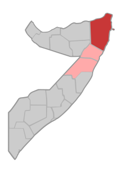
 Location in Eastern Somalia. |
|
| Coordinates: 6°6′47″N 47°59′17″E / 6.11306°N 47.98806°ECoordinates: 6°6′47″N 47°59′17″E / 6.11306°N 47.98806°E | |
| Country |
|
| State |
|
| Capital | Bosaso |
| Government | |
| • Type | Region |
| • Governor | Yusuf Mohamed Dhedo |
| Area | |
| • Total | 70,088 km2 (27,061 sq mi) |
| Time zone | EAT (UTC+3) |
| Area code(s) | 252 |
Bari (Somali: Bari, Arabic: باري) is an administrative region (gobol) in northeastern Somalia.
It is bordered by the Somali regions of Sanaag and Sool to the west, Nugal to the south, the Gulf of Aden to the north and the Indian Ocean to the east. It is located the tip of horn of Africa.
In terms of landmass, Bari is the largest province in the Federal Republic of Somalia. The highest point in this region is Mount Bahaya, the third tallest mountain in Somalia with an elevation of 2120 meters; other notable peaks include Karkaar.
Most of the inhabitants of the Bari region belong to the Somali ethnic group; in particular the Dishiishe, Majerteen and Warsangeli branches of the Harti and Meheri also Jambeel who live in northern Somali regions, the Leelkase Darod and the Madhiban. According 2015 census the population was 373,000 inhabitants.
In the official administrative divisions of Somalia, the Bari region consists of the following six districts:
In 1998, Bari became a part of Puntland, an autonomous region in northeastern Somalia. In the Transitional Constitution of the Puntland Regional Government of 2001, Puntland's territory is defined in terms of Somalia's official regions, Bari being one of them.
...
Wikipedia
