Bardwell, Kentucky
| Bardwell, Kentucky | |
|---|---|
| City | |

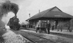
A train arrives at Bardwell's Illinois Central station, circa 1910.
|
|
 Location of Bardwell, Kentucky |
|
| Coordinates: 36°52′22″N 89°0′36″W / 36.87278°N 89.01000°WCoordinates: 36°52′22″N 89°0′36″W / 36.87278°N 89.01000°W | |
| Country | United States |
| State | Kentucky |
| County | Carlisle |
| Area | |
| • Total | 0.9 sq mi (2.3 km2) |
| • Land | 0.9 sq mi (2.3 km2) |
| • Water | 0.0 sq mi (0.0 km2) |
| Elevation | 361 ft (110 m) |
| Population (2010) | |
| • Total | 723 |
| • Density | 830/sq mi (320.6/km2) |
| Time zone | Central (CST) (UTC-6) |
| • Summer (DST) | CDT (UTC-5) |
| ZIP code | 42023 |
| Area code(s) | 270 & 364 |
| FIPS code | 21-03664 |
| GNIS feature ID | 0486336 |
Bardwell is a home rule-class city in and the county seat of Carlisle County, Kentucky, United States. The city was formally incorporated by the state assembly in 1878. The population was 723 at the 2010 census, down from 799 in 2000.
Bardwell was founded in the mid-1870s when the railroad was extended to that point.
During their session of 1877–1878, the Kentucky General Assembly passed an act incorporating Bardwell. The original municipal boundaries consisted of a circle with a radius of 0.5 miles (0.80 km), centered on the local train station for the Illinois Central Railroad.
Bardwell is located northwest of the center of Carlisle County at 36°52′22″N 89°0′36″W / 36.87278°N 89.01000°W (36.872690, -89.010026). U.S. Routes 51 and 62 intersect in the northern part of the city. US 51 leads south 29 miles (47 km) to Fulton on the Tennessee line, while US 62 leads northeast 30 miles (48 km) to Paducah on the Ohio River. The two highways together lead northwest 8 miles (13 km) to Wickliffe on the Mississippi River.
...
Wikipedia
