Bangkhuntien
|
Bang Khun Thian บางขุนเทียน |
|
|---|---|
| Khet | |

Rama II road
|
|
 Khet location in Bangkok |
|
| Coordinates: 13°39′39″N 100°26′9″E / 13.66083°N 100.43583°ECoordinates: 13°39′39″N 100°26′9″E / 13.66083°N 100.43583°E | |
| Country | Thailand |
| Province | Bangkok |
| Seat | Samae Dam |
| Khwaeng | 2 |
| Area | |
| • Total | 120.687 km2 (46.598 sq mi) |
| Population (2017) | |
| • Total | 182,235 |
| • Density | 1,509.98/km2 (3,910.8/sq mi) |
| Time zone | ICT (UTC+7) |
| Postal code | 10150 |
| Geocode | 1021 |
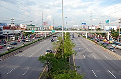
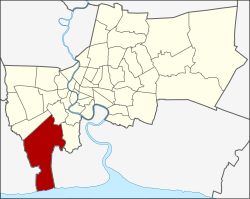
Bang Khun Thian (Thai: บางขุนเทียน, pronounced [bāːŋ kʰǔn tʰīa̯n]) is one of the 50 districts (khet) of Bangkok, Thailand. Its neighbors, clockwise from the north, are Bang Bon, Chom Thong, and Thung Khru Districts of Bangkok, Amphoe Phra Samut Chedi of Samut Prakan Province and Amphoe Mueang of Samut Sakhon Province. Bang Khun Thian is Bangkok's southernmost district, and the only one bordering the Gulf of Thailand.
Bang Khun Thian is an old district, believed to have been established in 1867 as an amphoe of Thonburi.
In 1972, Thonburi and Phra Nakhon Provinces were combined into Bangkok metropolis. Administrative units in the newly combined capital province were renamed from amphoe and tambon to "district" (khet) and "sub-district" (khwaeng). Thus, Bang Khun Thian became a district of Bangkok, composed of seven sub-districts: Bang Khun Thian, Bang Kho, Chom Thong, Bang Mot, Tha Kham, Bang Bon, and Samae Dam.
Due to population increases, a portion of Bang Khun Thian District was set up with its own district office and called Bang Khun Thian Branch 1. This new unit oversaw four sub-districts: Bang Khun Thian, Bang Kho, Bang Mot, and Chom Thong. In 1989, Bang Khun Thian Branch 1 was made a full district called Chom Thong District. In 1997, Bang Bon sub-district was separated from Bang Khun Thian and became its own district.
The district is divided into two sub-districts (khwaeng).
...
Wikipedia
