Bandarban District
|
Bandarban বান্দরবান |
|
|---|---|
| District | |

Bandarban skyline. From Nilgiri resort.
|
|
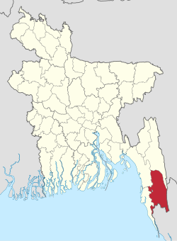
 Location of Bandarban in Bangladesh |
|
| Coordinates: 21°48′N 92°24′E / 21.800°N 92.400°ECoordinates: 21°48′N 92°24′E / 21.800°N 92.400°E | |
| Country |
|
| Division | Chittagong Division |
| As a District | 18 April 1981 |
| Government | |
| • Mayor of Bandarban Township | Mr. Islam Baby |
| • Mayor of Lama Township | Mr. Tanvir Hossain |
| Area | |
| • Total | 4,479.01 km2 (1,729.36 sq mi) |
| Population (2011 census) | |
| • Total | 388,335 |
| • Density | 87/km2 (220/sq mi) |
| Literacy rate | |
| • Total | 43% |
| Time zone | BST (UTC+6) |
| Website | bandarban |
Bandarban (Bengali: বান্দরবান) is a district in South-Eastern Bangladesh, and a part of the Chittagong Division. It is one of the three districts that make up the Chittagong Hill Tracts, the others being Rangamati District and Khagrachhari District. Bandarban is regarded as one of the most attractive travel destinations in Bangladesh. Bandarban (meaning the dam of monkeys), or in Marma or Arakanese language as "Rwa-daw Mro" is also known as Arvumi or the Bohmong Circle (of the rest of the three hill districts Rangamati is the Chakma Circle, Raja Devasish Roy and Khagrachari is the Mong Circle, Raja Sachingprue Marma). Bandarban town is the home town of the Bohmong Chief (currently King, or Raja, U Cho Prue Marma) who is the head of the Marma population. It also is the administrative headquarters of Bandarban district, which has turned into one of the most exotic tourist attractions in Bangladesh.
One of the three hill districts of Bangladesh and a part of the Chittagong Hill Tracts, Bandarban (4,479 km²) is not only the remotest district of the country, but also is the least populated (population 292,900) one. All of the highest peaks of Bangladesh are located at Bandarban district. Their heights measured with Garmin GPSMAP60CSX GPS are as follows:
Raikhiang Lake, the highest lake in Bangladesh is also found in Bandarban. Chimbuk peak and Boga Lake are two more highly noted features of the district. The newly reported highest peak of Bangladesh - Saka Haphong (3488 ft) is also here in Thanchi upazila.
Bandarban Sadar, Thanchi, Lama, Naikhongchhari, Ali kadam, Rowangchhari, and Ruma are the administrative sub-districts of Bandarban. Major road routes are:
...
Wikipedia
