Bandō, Ibaraki
|
Bandō 坂東市 |
|||
|---|---|---|---|
| City | |||

Bandō city hall
|
|||
|
|||
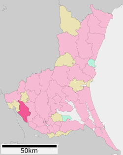
 Location of Bandō in Ibaraki Prefecture |
|||
| Coordinates: 36°2′54.3″N 139°53′19.4″E / 36.048417°N 139.888722°ECoordinates: 36°2′54.3″N 139°53′19.4″E / 36.048417°N 139.888722°E | |||
| Country | Japan | ||
| Region | Kantō | ||
| Prefecture | Ibaraki Prefecture | ||
| Area | |||
| • Total | 123.03 km2 (47.50 sq mi) | ||
| Population (September 2015) | |||
| • Total | 54,349 | ||
| • Density | 442/km2 (1,140/sq mi) | ||
| Time zone | Japan Standard Time (UTC+9) | ||
| - Tree | Zelkova serrata | ||
| - Flower | Tea | ||
| - Bird | Japanese bush warbler | ||
| Phone number | 0297-35-2121 | ||
| Address | Iwai 4365, Bando City, Ibaraki Prefecture 306-0692 | ||
| Website | Official website | ||
Bandō (坂東市 Bandō-shi?) is a city located in Ibaraki Prefecture, in the northern Kantō region of Japan. As of September 2015, the city had an estimated population of 54,349 and a population density of 442 persons per km². Its total area was 123.03 km².
Bandō is located in far southwestern Ibaraki Prefecture, on the north bank of the Tone River, bordered by Chiba Prefecture to the southwest. It is approximately 50 kilometers northeast of Tokyo.
The area of modern Bandō was part of Shimōsa Province until the start of the Meiji period. With the establishment of the municipalities system on April 1, 1889, the village of Iwai was created within Sashima District, Ibaraki. Iwai was elevated to town status on July 4, 1900 and to city status on April 1, 1972. The city of Bandō was established on March 22, 2005, from the merger of the city of Iwai with the neighoring town of Sashima.
...
Wikipedia


