Ban Pong District
|
Ban Pong บ้านโป่ง |
|
|---|---|
| District (Amphoe) | |

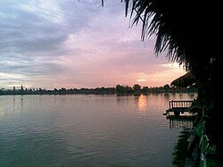
Lakeside restaurants at sunset. Bueng, Nong Kop, Ban Pong District
|
|
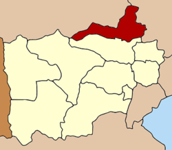
 District location in Ratchaburi Province |
|
| Coordinates: 13°48′51″N 99°52′16″E / 13.81417°N 99.87111°ECoordinates: 13°48′51″N 99°52′16″E / 13.81417°N 99.87111°E | |
| Country | Thailand |
| Province | Ratchaburi |
| Area | |
| • Total | 366.6 km2 (141.5 sq mi) |
| Population (2543) | |
| • Total | 157,689 |
| • Density | 430.1/km2 (1,114/sq mi) |
| Time zone | ICT (UTC+7) |
| Postal code | 70110 |
| Geocode | 7005 |
Ban Pong (Thai: บ้านโป่ง, pronounced [bâːn pòːŋ]) is a district (amphoe) of Ratchaburi Province, Thailand. It is in the northeast of the province.
Neighboring districts are (from the north clockwise) Tha Muang and Tha Maka of Kanchanaburi Province, Kamphaeng Saen and Mueang Nakhon Pathom of Nakhon Pathom Province, and Photharam of Ratchaburi Province.
Ban Pong District is hilly in the very western part of the district, while the eastern part is flooded plain with the Mae Klong River running through the city centre, connecting the city to the Gulf of Thailand.
Mon people settled in the Ban Pong area about four centuries ago. The Mon communities have maintained some of their traditions and have built their own Buddhist temples Later the town attracted a great number of Chinese immigrants as well. Also many Lao Wiang communities settled in the Nong Kop sub-district of rural Ban Pong.
During the construction of the Burma Railway in World War II Ban Pong was the site of one of the POW camps, Nong Pladuk Camp.
Ban Pong town experienced two great fires which razed the town centre, one in 1936 and the other in 1954. The town was rebuilt in the square-grid design then fashionable, with a fountain to the south and a clock tower to the north.
...
Wikipedia
