Ballygowan
Ballygowan
|
|
|---|---|
 |
|
| Ballygowan shown within County Down | |
| Population | 2,957 (2011 Census) |
| District | |
| County | |
| Country | Northern Ireland |
| Sovereign state | United Kingdom |
| Post town | NEWTOWNARDS |
| Postcode district | BT23 |
| Dialling code | 028 |
| EU Parliament | Northern Ireland |
| UK Parliament | |
| NI Assembly | |
| Website | http://www.ballygowan.org.uk/ |
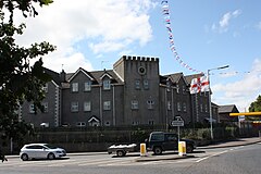
Ballygowan (from Irish Baile Mhic Gabhann, meaning 'MacGabhann's town') is a village and townland in County Down, Northern Ireland. It is within the Borough of Ards. The town of Comber is a short distance to the north-east, the town of Saintfield to the south, and the city of Belfast a further distance to the north-west. It is situated in the townland of the same name, the civil parishes of Killinchy and Comber and the historic barony of Castlereagh Lower. Ballygowan is a busy commuter bypass and is said to border the 'Greater Belfast City District' providing excellent travelling distance to Belfast City Centre. Ballygowan is said to one of the most wealthy districts of County Down (based on household income), similar to that of North Down (Northern Ireland's most affluent borough). It had a population of 2,957 people in the 2011 Census.
Prior to the Ulster-Scots settlement in the early 17th century, when a great number of Presbyterians moved over from the Scottish Lowlands to settle in North Down on lands granted by King James I to James Hamilton and Hugh Montgomery, the area surrounding Ballygowan was sparsely inhabited by subsepts of the great 'Neill clan of Castlereagh. Since the late 17th century the population has been predominantly Presbyterian.
...
Wikipedia

