Ballarat East
|
Ballarat East Ballarat, Victoria |
|||||||||||||||
|---|---|---|---|---|---|---|---|---|---|---|---|---|---|---|---|

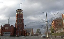
Former East Ballarat Civic Area on the corner of Barkly and East Streets. The Ballarat Fire Station is on the left, the old Library and Ballarat Secondary College are on the right.
|
|||||||||||||||
| Coordinates | 37°33′48″S 143°52′08″E / 37.5632°S 143.869°ECoordinates: 37°33′48″S 143°52′08″E / 37.5632°S 143.869°E | ||||||||||||||
| Population | 5,623 (2016 census) | ||||||||||||||
| Postcode(s) | 3350 | ||||||||||||||
| Location | 3 km (2 mi) from Ballarat Central | ||||||||||||||
| LGA(s) | City of Ballarat | ||||||||||||||
| State electorate(s) | |||||||||||||||
| Federal Division(s) | Ballarat | ||||||||||||||
|
|||||||||||||||
Ballarat East is a suburb of Ballarat in Victoria, Australia. Until 1921 the suburb was its own town with its own council, Ballarat East Town Council. The suburb covers a large area east of the City of Ballarat. It is the oldest area in Ballarat and was the site of many goldmines, as well as the Eureka Rebellion. The population of Ballarat East at the 2016 census was 5,628. Although amalgamation between Ballarat and Ballarat East occurred nearly a century ago the former town retains much of its shambolic character. It is notable for its contrast with present day Ballarat. In particular, it has windy roads which arose organically in the goldfields because the town was not planned and its has many old miner's cottages. However, much of its public infrastructure has been demolished, including the town hall, the train station and the orphanage. Much of the suburb is subject to heritage overlays because of its local significance, with most dwellings dating between the 1860s and 1940s.
The residents of Ballarat East played an integral role in the Eureka Rebellion and Battle of Eureka Stockade, although the site of this battle is now an island suburb within the East called Eureka.
The discovery of goldfields in 1851 led to heavy immigration. In 1854, in their resistance of an arbitrary tax, gold miners in the area came into armed conflict with the authorities. A commission was appointed to investigate their grievances and a charter was granted to the town in 1855. Ballarat East Post Office opened on 1 December 1857 and was replaced by the Bakery Hill office in 1992. The Ballarat East goldfield, which consisted of three distinct areas known as Ballarat East, Ballarat West and Nerrina, produced over 1.9 million ounces of gold from vein systems and over 16 million ounces from adjacent alluvial deposits. At the turn of the 20th century, these alluvial goldfields were the richest ever opened. As these surface deposits were exhausted the quartz reefs at deep levels were exploited and several mines worked at depths exceeding 600 metres.
Main Street developed into the principal commercial area in the Ballarat district. Its mostly tents and timber buildings were destroyed by a series of fires during the 1860s and the commercial area shifted to the planned area of Ballarat West, specifically Sturt and Lydiard Streets.
...
Wikipedia

