Ball's Bluff Battlefield and National Cemetery
|
Ball's Bluff Battlefield and National Cemetery
|
|

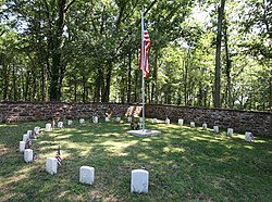
The circle of 25 graves at Ball's Bluff
|
|
| Location | Loudoun County, Virginia, USA |
|---|---|
| Nearest city | Leesburg, Virginia |
| Coordinates | 39°07′55″N 77°31′47″W / 39.13194°N 77.52972°WCoordinates: 39°07′55″N 77°31′47″W / 39.13194°N 77.52972°W |
| Area | 76 acres (31 ha) |
| NRHP Reference # | 84003880 |
| VLR # | 253-5021 |
| Significant dates | |
| Added to NRHP | April 27, 1984 |
| Designated NHLD | April 27, 1984 |
| Designated VLR | October 16, 1984 |
Ball's Bluff Battlefield Regional Park and National Cemetery is a battlefield area and a United States National Cemetery, located 2 miles (3.2 km) northeast of Leesburg, Virginia. The cemetery is the third smallest national cemetery in the United States. Fifty-four Union Army dead from the Battle of Ball's Bluff are interred in 25 graves in the half-acre plot; the identity of all of the interred except for one, James Allen of the 15th Massachusetts, are unknown. Monuments to fallen Confederate Sergeant Clinton Hatcher and Union brigade commander Edward Dickinson Baker are located next to the cemetery, though neither is buried there. While the stone wall-enclosed cemetery itself is managed through the Culpeper National Cemetery and owned by the Department of Veterans Affairs, the balance of the 223-acre (0.90 km2) park is managed through the Northern Virginia Regional Park Authority.
The Battle of Ball's Bluff was a small but consequential defeat for the Union early in the American Civil War, occurring just months after the Union Army's rout after the First Battle of Bull Run and another embarrassing loss at Battle of Wilson's Creek in the Western Theater. The Union defeat at Ball's Bluff revealed something to the public about the political nature of Union appointments of officers and their occasional incompetence, and led directly to the creation of the Joint Committee on the Conduct of the War.
...
Wikipedia


