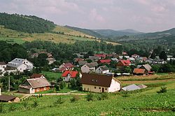
Baligrod
| Baligród | ||
|---|---|---|
| Village | ||

Baligród
|
||
|
||
| Coordinates: 49°19′50″N 22°17′07″E / 49.33056°N 22.28528°E | ||
| Country | Poland | |
| Voivodeship | Subcarpathian Voivodeship | |
| County | Lesko County | |
| Founded | 1615 | |
| Area | ||
| • Total | 68.8 km2 (26.6 sq mi) | |
| Elevation | 340 m (1,120 ft) | |
| Population | ||
| • Total | 1,468 | |
Baligród [baˈlʲiɡrut] (Ukrainian: Балигород, Balyhorod) is a village in Lesko County, in the Subcarpathian Voivodeship (province) of south-eastern Poland. It is also the seat of the municipality (gmina) called Gmina Baligród. Location: 49°21' N 22°17' E. From 1 January 1999 until 1 January 2002 it was located in Bieszczady County.
Baligród is a village situated in the valley of the Hoczewka river, near the Bieszczady mountains. Earlier Baligród was a small town but declined in population over the last century.
The settlement was first mentioned in 1615. It is believed to have been established at the beginning of the 17th century near a castle built by the Bal family. In 1634 the town previously called Balówgród received Magdeburg rights and privileges for markets, fairs and wine storage. Baligród remained in the Bal family until 1770. The town was situated on an often traveled trade route to Hungary. This enhanced opportunities for greater economic development. However the town began to later decline and in 1915 lost its municipal rights. The Baligród region was home to a large Ukrainian community, consisting of Lemkos and Boykos.
Between 1914 and 1915, during World War I, Baligród was partially destroyed. During World War II the village was once again partially damaged and many of its inhabitants were killed.
...
Wikipedia


