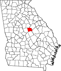
Baldwin County, Georgia
| Baldwin County, Georgia | |
|---|---|
 Location in the U.S. state of Georgia |
|
 Georgia's location in the U.S. |
|
| Founded | 1803 |
| Named for | Abraham Baldwin |
| Seat | Milledgeville |
| Largest city | Milledgeville |
| Area | |
| • Total | 267 sq mi (692 km2) |
| • Land | 258 sq mi (668 km2) |
| • Water | 9.6 sq mi (25 km2), 3.6% |
| Population | |
| • (2010) | 45,720 |
| • Density | 177/sq mi (68/km²) |
| Congressional district | 10th |
| Time zone | Eastern: UTC-5/-4 |
| Website | www |
Baldwin County is a county located in the U.S. state of Georgia. As of the 2010 census, the population was 46,337. The county seat is Milledgeville.
Baldwin County is part of the Milledgeville, GA Micropolitan Statistical Area.
For centuries the land was occupied by the Creek Nation, and for thousands of years before them, varying cultures of indigenous peoples.
Part of the land ceded by the Creek Nation in the Treaty of Fort Wilkinson in 1802 was used to create Baldwin County on May 11, 1803, by the Georgia General Assembly, the state's legislative body.
The land west of the Oconee River was organized as Baldwin and Wilkinson counties. The Treaty of Washington with the Creek in 1805 extended the state's western boundary to the Ocmulgee River. A legislative act on June 26, 1806, added some of this additional land to both counties.
The state legislature subsequently passed an act on December 10, 1807 that created four new counties from Baldwin County's 1806 borders. It expanded Baldwin to the east with land from Hancock and Washington counties. The new counties were Morgan, Jones, Putnam, and present-day Jasper (originally named Randolph County at the time of the act).
...
Wikipedia
