Balangiga, Eastern Samar
| Balangiga | |
|---|---|
| Municipality | |
 |
|
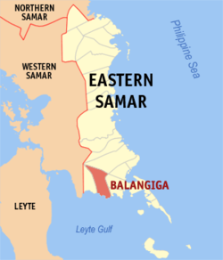
 Map of Eastern Samar with Balangiga highlighted |
|
| Location within the Philippines | |
| Coordinates: 11°07′N 125°23′E / 11.12°N 125.38°ECoordinates: 11°07′N 125°23′E / 11.12°N 125.38°E | |
| Country | Philippines |
| Region | Eastern Visayas (Region VIII) |
| Province | Eastern Samar |
| District | Lone district of E. Samar |
| Barangays | 13 |
| Government | |
| • Mayor | Viscuso S. de Lira |
| Area | |
| • Total | 190.05 km2 (73.38 sq mi) |
| Population (2015 census) | |
| • Total | 14,085 |
| • Density | 74/km2 (190/sq mi) |
| Time zone | PST (UTC+8) |
| ZIP code | 6812 |
| IDD : area code | +63 (0)55 |
| Website | www |
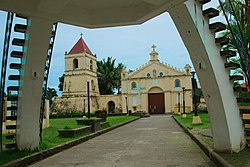
Balangiga is a fourth class municipality in the province of Eastern Samar, Philippines. As of the 2015 census, it had a population of 14,085 people.
Balangiga is the site of the Balangiga massacre in 1901, which remains one of the longest-running and most controversial issues of the Philippine–American War.
Balangiga is located on the southern coast of the island of Samar facing Leyte Gulf, and sits at the mouth of the Balangiga River. To the west lies the municipality of Lawaan, to the north is Llorente, and to the east are the municipalities of Quinapondan and Giporlos.
Balangiga is politically subdivided into 13 barangays.
In the 2015 census, the population of Balangiga, Eastern Samar, was 14,085 people, with a density of 74 inhabitants per square kilometre or 190 inhabitants per square mile.
Balangiga can be reached through public utility vans and buses from Tacloban City. Pedicabs (potpot), tricycles, and habal-habal by the means of inner town transportation.
Balangiga has 9 public elementary schools, namely:
Has 1 public secondary school:
Has 1 private secondary school:
The municipalities of Lawaan, Giporlos, and Quinapondan were former barangays of the municipality of Balangiga.
...
Wikipedia

