Bais, Negros Oriental
| Bais | ||
|---|---|---|
| Component City | ||
| City of Bais | ||

Old locomotive in Bais City
|
||
|
||
| Nickname(s): Sugar Estate of the South | ||
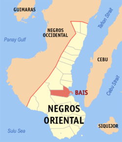
 Map of Negros Oriental showing the location of Bais |
||
| Location within the Philippines | ||
| Coordinates: 09°35′N 123°07′E / 9.583°N 123.117°ECoordinates: 09°35′N 123°07′E / 9.583°N 123.117°E | ||
| Country | Philippines | |
| Region | Negros Island Region (NIR/Region XVIII) | |
| Province | Negros Oriental | |
| District | 2nd district of Negros Oriental | |
| Cityhood | September 7, 1968 | |
| Barangays | 35 | |
| Government | ||
| • Mayor | Mercedes Teves Goñi | |
| • Vice Mayor | Miguel Real | |
| Area | ||
| • Total | 319.64 km2 (123.41 sq mi) | |
| Population (2010) | ||
| • Total | 74,722 | |
| • Density | 230/km2 (610/sq mi) | |
| Time zone | PST (UTC+8) | |
| ZIP code | 6206 | |
| Area code | 35 | |
| Income class | 3rd class | |
Bais, officially City of Bais, is a third class city in the province of Negros Oriental, Philippines. According to the 2015 census, it had a population of 76,291 people. Located 45 kilometres (28 mi) from the provincial capital Dumaguete, it has a land area of 31,964 hectares (78,980 acres).
There are two bays in the area, hence the name "Bais." The shore line is mostly mangroves, which are in danger of destruction due to the increasing population. The richness of marine life in the bays is because of these mangroves.
Bais City's bays are widely known to have one of the most beautiful coral reefs in the area.
The Pelarta River runs beside the city center. There is, however, a dispute that the name Bais was taken after the eels locally called "bais" that used to thrive in this river. The river has been the source of irrigation water for the nearby sugar farms. This has been vital in the success of sugar plantations in this area. This river also has a big influence on the city's geography, as it deposits sediments in the former mangrove areas during the (formerly annual) flood season. These former mangrove swamps have now dried out and become populated with residents. In the late 1970s, under the Genaro Goñi administration, a river control system stretching from the city center toward the low-lying areas was established in order to lessen flooding during the rainy season.
Bais City is politically subdivided into 35 barangays.
In the early days of Spanish exploration, some Spaniards came upon a swampy land and docked their boats at the vicinity of the two small islets that guarded the village. While exploring the place, they saw natives fishing along the coast. The Spaniards approached the natives and asked for the name of the place. The natives could not understand Spanish,and believing that the Spaniards were asking for the name of their catch, the natives answered saying "Ba-is"; from that day on, this swampy valley of the Old Panlabangan and Talamban Hills became known as Bais.
Negros Oriental's economy was far from progressive, and its rich soil was not utilized to its full capacity. That was in the 1850s. During those years, people in Negros depict a life of content for they tend to produce goods enough only to meet their daily needs. Even before the sugar boom of the 1850s, Negros Oriental was already producing sugar. The transport of most of its product was mainly done in the ports of Iloilo, which explains the fast moving pace of development of the sugar industry in Negros Occidental, primarily due to its proximity to Iloilo. This situation was a disadvantage on the movement of sugar from the Oriental plantations.
...
Wikipedia


