Bainbridge, Georgia
| Bainbridge, Georgia | |
|---|---|
| City | |
| City of Bainbridge | |

Bainbridge City Hall
|
|
| Motto: "Georgia's First Inland Port" | |
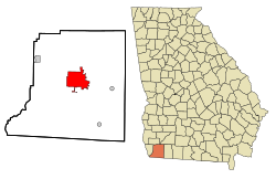
 Location in Decatur County and the state of Georgia |
|
| Coordinates: 30°54′17″N 84°34′16″W / 30.90472°N 84.57111°WCoordinates: 30°54′17″N 84°34′16″W / 30.90472°N 84.57111°W | |
| Country | United States |
| State | Georgia |
| County | Decatur |
| Government | |
| • Mayor | Edward Reynolds |
| Area | |
| • City | 20.1 sq mi (52.0 km2) |
| • Land | 18.8 sq mi (48.7 km2) |
| • Water | 1.3 sq mi (3.3 km2) |
| Elevation | 121 ft (37 m) |
| Population (2010) | |
| • City | 12,697 |
| • Density | 675/sq mi (260.8/km2) |
| • Metro | 27,842 |
| Time zone | Eastern (EST) (UTC-5) |
| • Summer (DST) | EDT (UTC-4) |
| ZIP code | 39817,39819 |
| Area code(s) | 229 |
| FIPS code | 13-04896 |
| GNIS feature ID | 0354431 |
| Website | bainbridgecity |
Bainbridge is a city in Decatur County, Georgia, United States. The city is the county seat of Decatur County. As of the 2010 census, the city had a population of 12,697.
The town was named after U.S. Navy Commodore William Bainbridge, commander of the USS Constitution ("Old Ironsides"), and was incorporated on December 22, 1829.
In 1824, Bainbridge was designated seat of the newly formed Decatur County.
Bainbridge is located in the center of Decatur County. The city is in southwestern Georgia along U.S. Routes 27 and 84, which form a bypass around the southern part of the city. Bainbridge is 40 miles (64 km) northwest of Tallahassee, Florida; 82 miles (132 km) west of Valdosta; and 54 miles (87 km) east-southeast of Dothan, Alabama.
According to the United States Census Bureau, the city has a total area of 20.1 square miles (52.0 km2), of which 18.8 square miles (48.7 km2) is land and 1.3 square miles (3.3 km2), or 6.40%, is water.
Bainbridge is located on the Flint River, which flows southwest to meet the Chattahoochee. Together they form the Apalachicola River which flows to the Gulf of Mexico. At the junction of the two rivers, the Jim Woodruff Dam forms Lake Seminole. A system of locks at the dam allows barge traffic to travel between the inland port at Bainbridge and the Gulf of Mexico.
...
Wikipedia
