Baie-Mahault
| Baie-Mahault | ||
|---|---|---|
| Commune | ||

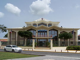
The town hall of Baie-Mahault
|
||
|
||
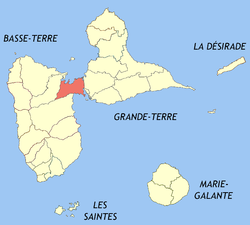
 Location of the commune (in red) within Guadeloupe |
||
| Coordinates: 16°16′N 61°35′W / 16.27°N 61.58°WCoordinates: 16°16′N 61°35′W / 16.27°N 61.58°W | ||
| Country | France | |
| Overseas region and department | Guadeloupe | |
| Arrondissement | Basse-Terre | |
| Canton | Baie-Mahault | |
| Government | ||
| • Mayor (2001–2007) | Ary Chalus | |
| Area1 | 46.00 km2 (17.76 sq mi) | |
| Population (2013)2 | 30,548 | |
| • Density | 660/km2 (1,700/sq mi) | |
| INSEE/Postal code | 97103 /97122 | |
| Elevation | 0–112 m (0–367 ft) | |
|
1 French Land Register data, which excludes lakes, ponds, glaciers > 1 km² (0.386 sq mi or 247 acres) and river estuaries. 2Population without double counting: residents of multiple communes (e.g., students and military personnel) only counted once. |
||
1 French Land Register data, which excludes lakes, ponds, glaciers > 1 km² (0.386 sq mi or 247 acres) and river estuaries.
Baie-Mahault is a commune in France and is the second most populated commune in the French overseas region and department of Guadeloupe after Les Abymes The extensive industrial zone of Jarry in Baie-Mahault is by far the most industrialized commune in the islands and the largest industrial park in the Lesser Antilles. It is part of the urban area of Pointe-à-Pitre, the largest metropolitan area in Guadeloupe, located in the northwest.
The inhabitants of Baie-Mahault are called Baie-Mahaultiens.
Baie-Mahault may be named for a variety of mangrove called mahault or mahot common in this area.
On 29 November 1808, during the Napoleonic Wars, boats from HMS Heureux attacked French vessels in the harbour and the batteries protecting them. The captain of Heureux was killed and one of his men was wounded. The British succeeded in destroying the guns of one of the two batteries, and in capturing a schooner.
In 1843 there was a severe earthquake. In October 1865, a cholera epidemic flared up. In Guadeloupe, from October 1865 to June 1866, 12,000 inhabitants perished. Mahault Bay was the first and worst hit by the epidemic.
In 1910, the Darboussier Factory was constructed. In 1918, the TSF radio station was built. An electric generating plant was built in 1934 which supplied Guadeloupe. The 1928 Okeechobee hurricane destroyed much of the town. The church and the presbytery were rebuilt in 1933. The Gabarre bridge and the industrial and commercial park of Jarry, the largest in Guadeloupe, were built. In 2001, Ary Chalus became mayor.
Baie-Mahault (Mangrove Bay) is located in the borough called Canton and it extends a vast plain of northeastern Basse-Terre Island, where it meets Grande-Terre. A channel, navigable by smaller boats, of from 30–100 yards across, called Riviere Salee or Salt River separates the two islands. The Baie-Mahault area sets in marshlands and marine cul-de-sacs. The town prospered through fertile arable lands used to grow sugar cane. The mangrove swamps are a few miles east at the Salt River. Baie-Mahault is 7 km (4.3 mi) northwest of the city of Pointe-à-Pitre and 8 km (5.0 mi) west of Pointe-à-Pitre International Airport.
...
Wikipedia

