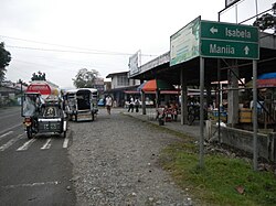
Bagabag, Nueva Vizcaya
|
Bagabag Bayan ng Bagabag |
||
|---|---|---|
| Municipality | ||
| Town of Bagabag | ||
 |
||
|
||
 Map of Nueva Vizcaya showing the location of Bagabag |
||
| Location within the Philippines | ||
| Coordinates: 16°36′N 121°16′E / 16.600°N 121.267°ECoordinates: 16°36′N 121°16′E / 16.600°N 121.267°E | ||
| Country | Philippines | |
| Region | Cagayan Valley (Region II) | |
| Province | Nueva Vizcaya | |
| District | Lone district | |
| Founded | 1741 | |
| Barangays | 17 | |
| Government | ||
| • Mayor | Johnny M. Sevillena | |
| Area | ||
| • Total | 183.90 km2 (71.00 sq mi) | |
| Population (2015) | ||
| • Total | 35,501 | |
| • Density | 190/km2 (500/sq mi) | |
| Time zone | PST (UTC+8) | |
| ZIP code | 3711 | |
| IDD : area code | +63 (0)78 | |
| Income class | 2nd class; partially urban | |
| Website | www |
|
Bagabag is a second class municipality in the province of Nueva Vizcaya, Philippines. The town is famous for its buko pie (coconut pie) in the Cagayan Valleyregion and it is the gateway to the world-famous Banaue Rice Terraces. According to the 2015 Philippine Census, it has a population of 35,501.
Bagabag is considered the pineapple region of Nueva Vizcaya. The main crops produced are rice, corn, coconut, mango, and pineapple. Bagabag has the largest tilapia farming in the region. Main resources include agriculture, livestock, and fruit-bearing trees plantation. Main industries include furniture, hollow block factory, tilapia farming, buko pie, pineapple vinegar, and meat processing. Located in the northern part of the town is Bagabag Airport, the only airport of Nueva Vizcaya, which serves the province and its surrounding area. Adjacent to the airport is the Summer Institutes of Linguistics (SIL) Bagabag.
Bagabag is 19 kilometres (12 mi) north of its provincial capital, Bayombong, and 290 kilometres (180 mi) north of its country capital, Manila. It is located in the northeastern part of Nueva Vizcaya with a total land area of 260 square kilometers or 26,000 hectares. The Magat River, which runs parallel to the Pan-Philippine Highway (AH 26), is situated in the eastern part of the town proper.
The town was formed on October 7, 1741 during the Spanish regime by a friar, Padre (Pe.) Antonio del Campo, at sitio "Nagcumventuan" a place now located between Pogonsino, Bagabag, Nueva Vizcaya and Bangar, Solano, Nueva Vizcaya. The present name of the sitio bears proof to the fact that the Spanish priest constructed a church in the original town site.
...
Wikipedia


